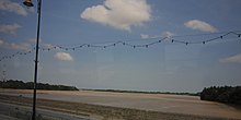
Pahang River
| Pahang River | |
|---|---|
 |
|
| Native name | Sungai Pahang |
| Country | Pahang, Malaysia |
| Basin features | |
| Main source | Titiwangsa Mountains |
| River mouth | Kuala Pahang |
| Basin size | 29,300 km2 (11,300 sq mi) |
| Physical characteristics | |
| Length | 459 km (285 mi) |
| Discharge |
|
The Pahang River (Malay: Sungai Pahang) is a river that flows through the state of Pahang, Malaysia. At 459 km in length, it is the longest river on the Malay Peninsula. The river begins at the confluence of Jelai and Tembeling rivers on the Titiwangsa Mountains and drains into the South China Sea.
From the upper slopes of Titiwangsa Mountains at Cameron Highlands, Jelai river flows in a southeasterly direction, passing through Padang Tengku and Kuala Lipis before merging with Tembeling river. Tembeling River which begins at Pahang and Terengganu state border at Ulu Tembeling, flows in a southwesterly direction passing through Kuala Tahan. Pahang River flows in a southerly direction passing through Jerantut Feri, Kuala Krau, Kerdau and Temerloh. At Mengkarak, the river turns to the northeast, passing through Chenor and then turning east at Lubuk Paku and Lepar into the floodplain of Paloh Hinai, Pekan and Kuala Pahang before draining into the South China Sea.
...
Wikipedia
