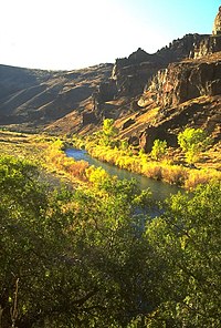
Owyhee River
| Owyhee River | |
| Country | United States |
|---|---|
| States | Nevada, Idaho, Oregon |
| City | Rome, Oregon |
| Source | Near Wild Horse |
| - location | Elko County, Nevada |
| - elevation | 6,860 ft (2,091 m) |
| - coordinates | 41°30′17″N 115°44′30″W / 41.50472°N 115.74167°W |
| Mouth | Snake River |
| - location | Canyon County, Idaho/Malheur County, Oregon |
| - elevation | 2,185 ft (666 m) |
| - coordinates | 43°48′46″N 117°01′32″W / 43.81278°N 117.02556°WCoordinates: 43°48′46″N 117°01′32″W / 43.81278°N 117.02556°W |
| Length | 346 mi (557 km) |
| Basin | 11,049 sq mi (28,617 km2) |
| Discharge | for Owyhee, OR, 1 mi (1.6 km) from the mouth |
| - average | 1,146 cu ft/s (32 m3/s) |
| - max | 29,000 cu ft/s (821 m3/s) |
| - min | 3.2 cu ft/s (0 m3/s) |
|
Map of the Owyhee River watershed
|
|
The Owyhee River is a tributary of the Snake River located in northern Nevada, southwestern Idaho and southeastern Oregon in the United States. It is 346 miles (557 km) long. The river's drainage basin is 11,049 square miles (28,620 km2) in area, one of the largest subbasins of the Columbia Basin. The mean annual discharge is 995 cubic feet per second (28.2 m3/s), with a maximum of 50,000 cu ft/s (1,400 m3/s) recorded in 1993 and a minimum of 42 cu ft/s (1.2 m3/s) in 1954.
The Owyhee drains a remote area of the arid plateau region on the north edge of the Great Basin, rising in northeastern Nevada and flowing generally northward near the Oregon-Idaho border to the Snake River. Its watershed is very sparsely populated. The Owyhee River and tributaries flow through the Owyhee Plateau, cutting deep canyons, often with vertical walls and in some places over 1,000 feet (300 m) deep.
The Owyhee River has its source in northeastern Nevada, in northern Elko County, approximately 50 miles (80 km) north of the city of Elko. It flows north along the east side of the Independence Mountains of Nevada, passing through Wild Horse Reservoir and then cutting northeast past the north end of the range. The river runs through the Humboldt National Forest, and then past the communities of Mountain City and Owyhee in the Duck Valley Indian Reservation. It then enters southwestern Idaho, flowing northwest for approximately 50 miles (80 km) across the southwest corner of the state through Owyhee County. It is then joined by the South Fork Owyhee River from the south, approximately 10 miles (16 km) east of the Oregon border. The main tributary of the South Fork is the Little Owyhee River.
...
Wikipedia


