Malheur County, Oregon
| Malheur County, Oregon | |
|---|---|

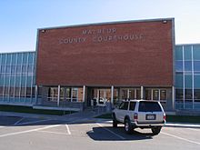
Malheur County Courthouse in Vale
|
|
 Location in the U.S. state of Oregon |
|
 Oregon's location in the U.S. |
|
| Founded | February 17, 1887 |
| Named for | Malheur River |
| Seat | Vale |
| Largest city | Ontario |
| Area | |
| • Total | 9,930 sq mi (25,719 km2) |
| • Land | 9,888 sq mi (25,610 km2) |
| • Water | 42 sq mi (109 km2), 0.4% |
| Population (est.) | |
| • (2015) | 30,380 |
| Congressional district | 2nd |
| Time zones |
Mountain: UTC-7/-6 North of 42.45° N latitude |
|
Pacific: UTC-8/-7 South of 42.45° N latitude |
|
| Website | www |
Malheur County /mælˈhɪər/ is a county located in the southeast corner of the U.S. state of Oregon. As of the 2010 census, the population was 31,313. Its county seat is Vale, and its largest city is Ontario. The county was named after the Malheur River, which runs through the county. "Malheur" is French for misfortune or tragedy.
Malheur County is included in the Ontario, OR-ID Micropolitan Statistical Area, which is also included in the Boise City-Mountain Home-Ontario, ID-OR Combined Statistical Area. It is included in the eight-county definition of Eastern Oregon.
Malheur County was created February 17, 1887, from the southern portion of Baker County. It was first settled by miners and stockmen in the early 1860s. The discovery of gold in 1863 attracted further development, including settlements and ranches. Basques settled in the region in the 1890s and were mainly engaged in sheep raising.
According to the U.S. Census Bureau, the county has a total area of 9,930 square miles (25,700 km2), of which 9,888 square miles (25,610 km2) is land and 42 square miles (110 km2) (0.4%) is water. It is the second-largest county in Oregon by area. It is the only county in Oregon in the Mountain Time Zone.
...
Wikipedia
