Owyhee County, Idaho
| Owyhee County, Idaho | ||
|---|---|---|

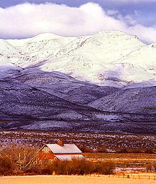
Reynolds Creek Experimental Watershed in the Owyhee Mountains about 50 miles southwest of Boise.
|
||
|
||
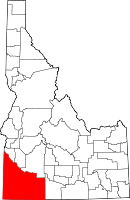
 Location in the U.S. state of Idaho |
||
 Idaho's location in the U.S. |
||
| Founded | December 31, 1863 | |
| Named for | lost Hawaiian trappers | |
| Seat | Murphy | |
| Largest city | Homedale | |
| Area | ||
| • Total | 7,697 sq mi (19,935 km2) | |
| • Land | 7,666 sq mi (19,855 km2) | |
| • Water | 31 sq mi (80 km2), 0.4% | |
| Population | ||
| • (2010) | 11,526 | |
| • Density | 1.5/sq mi (1/km²) | |
| Congressional district | 1st | |
| Time zone | Mountain: UTC-7/-6 | |
| Website | owyheecounty |
|
Owyhee County is a county located in the southwestern corner of the U.S. state of Idaho. As of the 2010 census, the population was 11,526. The county seat is Murphy, and its largest city is Homedale. In area it is the second-largest county in Idaho, behind Idaho County.
Owyhee County is part of the Boise, ID Metropolitan Statistical Area. It is the location of slightly more than 50% of the Duck Valley Indian Reservation, which extends over the border into Elko County, Nevada. The majority of the federally recognized Shoshone-Paiute Tribe that is associated with this reservation lives on the Nevada side; its tribal center is in Owyhee, Nevada.
This area was the territory of Western Shoshone, Northern Paiute and Bannock peoples and their ancestors for thousands of years prior to the arrival of Americans. Conflicts over land use and resources led to the indigenous peoples being pushed aside.
On December 31, 1863, Owyhee County became the first county organized by the Idaho Territory Legislature. While Boise, Idaho, Nez Perce and Shoshone counties were organized under the laws of Washington Territory, they were not recognized by the Idaho Territory until February 1864. The original county seat at Ruby City was moved to nearby Silver City in 1867.
Owyhee County's original boundary was the portion of Idaho Territory south of the Snake River and west of the Rocky Mountains. Less than a month after the creation of Owyhee County, Oneida County was formed in January 1864 from the eastern portion of the county. The formation of Cassia County in 1879 took further territory in the east.
...
Wikipedia

