
Otterndorf
| Otterndorf | ||
|---|---|---|
|
||

Otterndorf
|
||
|
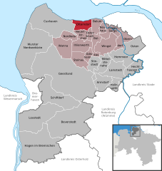
Location of Otterndorf within Cuxhaven district
  |
||
| Coordinates: 53°48′N 8°54′E / 53.800°N 8.900°ECoordinates: 53°48′N 8°54′E / 53.800°N 8.900°E | ||
| Country | Germany | |
| State | Lower Saxony | |
| District | Cuxhaven | |
| Municipal assoc. | Land Hadeln | |
| Government | ||
| • Mayor | Claus Johannßen (SPD) | |
| Area | ||
| • Total | 33.54 km2 (12.95 sq mi) | |
| Elevation | 0-6 m (−20 ft) | |
| Population (2015-12-31) | ||
| • Total | 7,230 | |
| • Density | 220/km2 (560/sq mi) | |
| Time zone | CET/CEST (UTC+1/+2) | |
| Postal codes | 21762 | |
| Dialling codes | 04751 | |
| Vehicle registration | CUX | |
| Website | www.otterndorf.de | |

Otterndorf is a town on the coast of the North Sea in the region of Lower Saxony, Germany, and is part of the Samtgemeinde Land Hadeln. The town is at the mouth of the river Medem on part of the Elbe delta in the district Cuxhaven. Otterndorf possesses many half timbered house in the old part of town which are worth seeing. Otterndorf is twinned with the town of Sheringham in the English county of Norfolk.
Otterndorf belongs to the Land of Hadeln, first an exclave of the younger Duchy of Saxony and after its de facto dynastic partition in 1296 of the Duchy of Saxe-Lauenburg, established de jure in 1260. The first written evidence of the town of Otterndorf dates from the year 1261 in a document written by Godefridus who was a Priest. In 1400, Otterndorf was granted city rights by Eric IV, Duke of Saxe-Lauenburg.
In 1728 Emperor Charles VI enfeoffed the George II Augustus and his House of Hanover in personal union with the reverted fief of Saxe-Lauenburg. By a redeployment of Hanoverian territories in 1731 the Hanoverian Duchies of Bremen and Verden were conveyed the administration of the neighboured Land of Hadeln. The Kingdom of Hanover incorporated the Land of Hadeln in a real union and its territory, including Otterndorf, became part of the new Stade Region, established in 1823.
...
Wikipedia