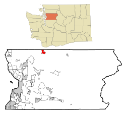
Oso, Washington
| Oso, Washington | |
|---|---|
| CDP | |
 Location of Oso, Washington |
|
| Coordinates: 48°16′20″N 121°55′9″W / 48.27222°N 121.91917°WCoordinates: 48°16′20″N 121°55′9″W / 48.27222°N 121.91917°W | |
| Country | United States |
| State | Washington |
| County | Snohomish |
| Area | |
| • Total | 3.7 sq mi (9.6 km2) |
| • Land | 3.6 sq mi (9.4 km2) |
| • Water | 0.1 sq mi (0.2 km2) |
| Elevation | 207 ft (63 m) |
| Population (2010) | |
| • Total | 180 |
| • Density | 69.0/sq mi (26.2/km2) |
| Time zone | Pacific (PST) (UTC-8) |
| • Summer (DST) | PDT (UTC-7) |
| ZIP code | 98223 |
| Area code | 360 |
| FIPS code | 53-52110 |
| GNIS feature ID | 1524091 |
Oso is a census-designated place (CDP) in Snohomish County, Washington, United States located west of Darrington, Washington, south of the North Fork of the Stillaguamish River and approximately 50 air miles (80 km) from Seattle. The population of Oso was 180 at the 2010 census. The community made international news as the site of a large landslide in March 2014.
Oso is located at 48°16′20″N 121°55′9″W / 48.27222°N 121.91917°W (48.272281, -121.919235).
According to the United States Census Bureau, the CDP has a total area of 3.7 square miles (9.6 km²), of which, 3.6 square miles (9.4 km²) of it is land and 0.1 square miles (0.2 km²) of it (2.43%) is water.
The town was originally named Allen, but was renamed to Oso to avoid confusion with Allyn in Mason County. Oso is Spanish for bear and was named by J. P. Britzius after the town of Oso, Texas in Fayette County. The Texas town no longer exists, having been abandoned in favor of the nearby town of Flatonia which had a railway station.
As of the census of 2000, there were 246 people, 96 households, and 69 families residing in the CDP. The population density was 68.0 people per square mile (26.2/km²). There were 102 housing units at an average density of 28.2/sq mi (10.9/km²). The racial makeup of the CDP was 99.19% White, 0.41% African American, and 0.41% from other races. Hispanic or Latino of any race were 0.41% of the population.
...
Wikipedia
