Mason County, Washington
| Mason County, Washington | ||
|---|---|---|

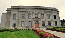
Mason County Courthouse
|
||
|
||
 Location in the U.S. state of Washington |
||
 Washington's location in the U.S. |
||
| Founded | March 13, 1854 | |
| Named for | Charles H. Mason | |
| Seat | Shelton | |
| Largest city | Shelton | |
| Area | ||
| • Total | 1,051 sq mi (2,722 km2) | |
| • Land | 959 sq mi (2,484 km2) | |
| • Water | 92 sq mi (238 km2), 8.7% | |
| Population (est.) | ||
| • (2015) | 61,023 | |
| • Density | 63/sq mi (24/km²) | |
| Congressional districts | 6th, 10th | |
| Time zone | Pacific: UTC-8/-7 | |
| Website | www |
|
Mason County is a county located in the U.S. state of Washington. As of the 2010 census, the population was 60,699. The county seat and only incorporated city is Shelton. The county was formed out of King County on March 13, 1854. Originally named Sawamish County, it took its present name in 1864 in honor of Charles H. Mason, the first Secretary of Washington Territory.
Mason County comprises the Shelton, WA Micropolitan Statistical Area and is included in the Seattle-Tacoma, WA Combined Statistical Area.
According to the U.S. Census Bureau, the county has a total area of 1,051 square miles (2,720 km2), of which 959 square miles (2,480 km2) is land and 92 square miles (240 km2) (8.7%) is water.
As of the census of 2000, there were 49,405 people, 18,912 households, and 13,389 families residing in the county. The population density was 51 people per square mile (20/km²). There were 25,515 housing units at an average density of 26 per square mile (10/km²). The racial makeup of the county was 88.46% White, 1.19% Black or African American, 3.72% Native American, 1.05% Asian, 0.45% Pacific Islander, 2.10% from other races, and 3.03% from two or more races. 4.78% of the population were Hispanic or Latino of any race. 16.7% were of German, 9.9% Irish, 9.8% English, 8.6% United States or American and 6.8% Norwegian ancestry.
...
Wikipedia

