Oshawa—Whitby
|
|
|||
|---|---|---|---|

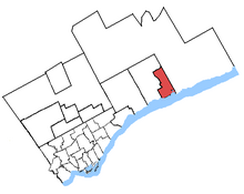
Oshawa in relation to other greater Toronto ridings (2003 boundaries)
|
|||
| Federal electoral district | |||
| Legislature | House of Commons | ||
| MP |
Conservative |
||
| District created | 1966 | ||
| First contested | 1968 | ||
| Last contested | 2015 | ||
| District webpage | profile, map | ||
| Demographics | |||
| Population (2011) | 125,771 | ||
| Electors (2015) | 94,928 | ||
| Area (km²) | 65 | ||
| Pop. density (per km²) | 1,934.9 | ||
| Census divisions | Durham | ||
| Census subdivisions | Oshawa | ||
Oshawa (formerly known as Oshawa—Whitby) is a federal electoral district in Ontario, Canada, that has been represented in the House of Commons of Canada since 1968.
It consists of the southern part of the City of Oshawa south of Taunton Road.
Ethnic groups: 89.8% White, 2.9% Black, 2.1% Aboriginal, 1.5% South Asian
Languages: 88.5% English, 2.5% French, 1.3% Polish
Religions: 67.9% Christian (28.8% Catholic, 11.3% United Church, 7.7% Anglican, 2.8% Pentecostal, 2.7% Baptist, 2.5% Presbyterian, 1.2% Christian Orthodox, 11.1% Other), 1.0% Muslim, 29.4% No religion
Median income (2010): $30,773
Average income (2010): $37,231
It was created as "Oshawa" riding in 1966 from parts of Ontario riding.
It consisted initially of the City of Oshawa, the Town of Whitby and the part of the Township of Whitby between the west limit of the City of Oshawa and the east limit of the Town of Whitby and lying south of the road allowance between Concessions 2 and 3. The name of the electoral district was changed in 1967 to "Oshawa—Whitby".
In 1976, Oshawa—Whitby riding was abolished, and a new "Oshawa" riding was created from parts of Durham, Ontario and Oshawa—Whitby ridings. It consisted of the City of Oshawa. In 1987, it was redefined to exclude the part of the city north of Rossland Road and the allowance for road in front of lots 1, 2, 3 and 4, Concession 3.
In 1996, it was defined as consisting of the part of the city to the south of a line drawn from west to east along Taunton Road, south along Ritson Road North, east along Rossland Road East, south along Harmony Road North and east along King Street East.
In 2003, it was given its current boundaries as described above, and Whitby-Oshawa was drawn out of Durham and Whitby—Ajax.
Oshawa lost territory to Durham, and gained territory from Whitby—Oshawa during the 2012 electoral redistribution.
...
Wikipedia
