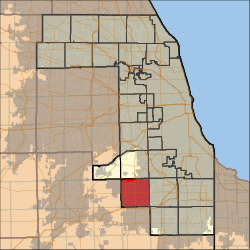
Orland Township, Cook County, Illinois
| Orland Township | |
|---|---|
| Township | |
 Location in Cook County |
|
 Cook County's location in Illinois |
|
| Coordinates: 41°36′06″N 87°51′13″W / 41.60167°N 87.85361°WCoordinates: 41°36′06″N 87°51′13″W / 41.60167°N 87.85361°W | |
| Country | United States |
| State | Illinois |
| County | Cook |
| Area | |
| • Total | 3 sq mi (94.45 km2) |
| • Land | 35.73 sq mi (92.55 km2) |
| • Water | 0.73 sq mi (1.89 km2) 2.00% |
| Elevation | 705 ft (215 m) |
| Population (2010) | |
| • Total | 97,558 |
| • Density | 2,730/sq mi (1,054.1/km2) |
| Time zone | CST (UTC-6) |
| • Summer (DST) | CDT (UTC-5) |
| ZIP codes | 60452, 60462, 60467, 60477 |
| GNIS feature ID | 0429505 |
| Website | orlandtownship |
Orland Township is one of 29 townships in Cook County, Illinois, USA. As of the 2010 census, its population was 97,558.
According to the United States Census Bureau, Orland Township covers an area of 36.47 square miles (94.5 km2); of this, 35.74 square miles (92.6 km2) (97.99 percent) is land and 0.73 square miles (1.9 km2) (1.89 square kilometers, 2 percent) is water. It includes the entire village of Orland Hills, almost all of Orland Park, as well as a large portion of Tinley Park.
Orland Township is bordered by Harlem Avenue (Illinois Route 43) on the east, 135th Street on the north, Will-Cook Road on the west (where Cook County and Will County share a border), and 183rd Street on the south (which is also the Cook-Will county border).
The township contains these four cemeteries: Cooper, German Methodist, Old German Methodist and Orland Park.
There are many political organizations in Orland Township. The Regular Democratic Organization for Orland Township, represents all Democratic candidates.
...
Wikipedia
