Orissa Province
| Orissa Province ଓଡ଼ିଶା |
|||||
| Province of British India | |||||
|
|||||
|
Flag |
|||||
| Orissa in a 1907 map of British India before the creation of the province | |||||
| History | |||||
| • | Bifurcation of Bihar and Orissa Province | 1936 | |||
| • | Independence of India | 1947 | |||
| Area | |||||
| • | 1901 | 35,664 km2(13,770 sq mi) | |||
| Population | |||||
| • | 1901 | 5,003,121 | |||
| Density | 140.3 /km2 (363.3 /sq mi) | ||||
| Today part of | State of Odisha | ||||
Flag
Orissa Province was a province of British India created in April 1936 by partition of the Bihar and Orissa Province. It is now the State of Odisha.
On 1 April 1912 Bihar and Orissa were separated from Bengal to form the Bihar and Orissa Province. On 1 April 1936, Bihar and Orissa Province was split to form Bihar Province and Orissa Province. Parts of the Ganjam District and the Vizagapatam District of Madras Presidency were transferred to Orissa Province along with portions of the Vizagapatam Hill Tracts Agency and Ganjam Hill Tracts Agency.
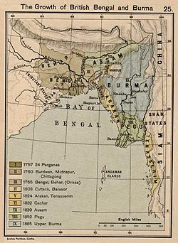
On 14 October 1803, Orissa was occupied by the British Raj. Under the Raj, it was a division of the Bengal Presidency with its capital in Cuttack. It had an area of 35,664 km² and 5,003,121 inhabitants in 1901. The province included the Orissa Tributary States. On 1 April 1912, the province of Bihar and Orissa was detached from Bengal, and the Orissa Tributary States were under the authority of the governor of Bihar and Orissa. In 1936, Orissa became a separate province with five districts.
The Government of India Act provided for the election of a provincial legislative assembly and a responsible government. Elections were held in 1937, and the Indian National Congress took a majority of the seats but declined to form the government. A minority provisional government was formed under Krushna Chandra Gajapati, the Maharaja of Paralakhemundi.
...
Wikipedia


