Ordubad (city)
| Ordubad | |
|---|---|
| City and Municipality | |

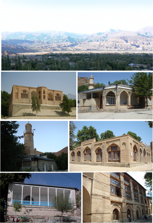
Top:Panorama view of Ordubad and mountain range area, 2nd left:Juma Moscue, 2nd right:Huseyinuh Moscue, 3rd left:Dirnis Moscue, 3rd right:Geysarriya Monument, Bottom left:Ambaras Moscue, Bottom right:Sarshahar Moscue
|
|
| Coordinates: 38°54′29″N 46°01′40″E / 38.90806°N 46.02778°ECoordinates: 38°54′29″N 46°01′40″E / 38.90806°N 46.02778°E | |
| Country |
|
| Autonomous republic | Nakhchivan Autonomous Republic |
| Rayon | Ordubad |
| Population | |
| • Total | 10,372 |
| Time zone | AZT (UTC+4) |
| Postal code | AZ6900 |
| Area code(s) | +994 036 |
Ordubad (also, Ordoubat and Ordubat), is the second largest town and a municipality of the Nakhchivan Autonomous Republic of Azerbaijan and is one of its three regions. It is the capital of the Ordubad rayon. Ordubad declared a medieval city of the Caucasus in its current capacity of a town was founded in the 18th century. The town is divided into five districts of the Ambaras, the Kurdtatal, the Mingis, the Sar sheher, and the Uch. Ordubad is known as the “pearl” of Nakhchevan province and is well known for its exports of fruits and spices, and for its cuisine.
Ordubad is a name of Turco-Persian origin and means "city of army" (from Turkic ordu (army) and Persian bad (city)), which implies that the city was founded during the period of the Mongol or the ensuing Il-Khanid rule.
The Ordubad city, known as the “pearl” of Nakhchevan province, is located at an elevation of 949 metres (3,114 ft). It is in the northern bank of the central stretch of the Araxes (Aras) river of the eastern Transcaucasia which earlier belonged to Persia, now in Azerbaijan. the second largest town. The Ordubad Province itself has an area of 972 square kilometres (375 sq mi) and is delimited by Iran on the south, Armenia forming the north and west border, and the Julfa region of Nakhchivan bordering the east. The river that rises from the north from the Mt. Qobān (also known as Tk. Qapïjïq, Rus. Kapudzhukh or Kapydzhik) at an elevation of 3,904 metres (12,808 ft) drains into the Araxes. The town is divided into five districts of the Ambaras, the Kurdtatal, the Mingis, the Sar sheher, and the Uch. The city has a large number of walnut and mulberry trees. The closest railway station is Ordubad and the distance to Nakhchivan city is 88 kilometres (55 mi). Tabriz is 94 kilometres (58 mi) away to the north-northwest.
...
Wikipedia

