Oppegård
| Oppegård kommune | |||
|---|---|---|---|
| Municipality | |||
|
|||
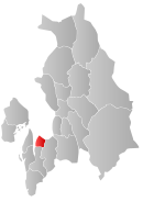
 Oppegård within Akershus |
|||
| Coordinates: 59°47′33″N 10°47′25″E / 59.79250°N 10.79028°ECoordinates: 59°47′33″N 10°47′25″E / 59.79250°N 10.79028°E | |||
| Country | Norway | ||
| County | Akershus | ||
| District | Follo | ||
| Administrative centre | Kolbotn | ||
| Government | |||
| • Mayor (1995) | Ildri Eidem Lovaas (H) | ||
| Area | |||
| • Total | 37 km2 (14 sq mi) | ||
| • Land | 34 km2 (13 sq mi) | ||
| Area rank | 424 in Norway | ||
| Population (2008) | |||
| • Total | 23,964 | ||
| • Rank | 37 in Norway | ||
| • Density | 681/km2 (1,760/sq mi) | ||
| • Change (10 years) | 8.0 % | ||
| Demonym(s) | Oppegårding | ||
| Time zone | CET (UTC+1) | ||
| • Summer (DST) | CEST (UTC+2) | ||
| ISO 3166 code | NO-0217 | ||
| Official language form | Bokmål | ||
| Website | www |
||
|
|
|||
Oppegård is a village and municipality in Akershus county, Norway. It is part of the traditional region of Follo. The administrative centre of the municipality is the village of Kolbotn. The new municipality of Oppegård was separated from the municipality of Nesodden on 1 July 1915. The municipality has an area of 37 square kilometres (14.3 sq mi), hence it is the smallest municipality in Akershus by area.
The municipality (originally the parish) is named after the old Oppegård farm (Old Norse: Uppigarđr), since the first church was built here. The first element is uppi which means "upper" and the last element is garđr which means "farm". (The farm is probably a part of an older and bigger farm.)
The coat-of-arms is from modern times. They were granted on 6 August 1976. The arms show 17 gold triangles on a black background. The 17 triangles symbolize 17 trees, which again symbolize the 17 old farms in the municipality. Most of the farms lie in an area called Svartskog ('black forest'), so the arms are canting arms.
Oppegård has been populated since the end of the last ice age. Archeological remains of hunter-gatherer societies dating back to 5000–6000 BCE have been found, as well as the remains of agriculatural settlements from 1000–2000 BCE. The main southern roads connecting Oslo to Sweden and Denmark have passed through Oppegård since the Iron Age.
The present-day municipality was created from the eastern part of the municipality of Nesodden in 1915. At the time, the population of Oppegård was only 600. The 1960s and 1970s saw a population boom, as larger housing projects established the Oppegård villages as suburbs of Oslo. The commercial centres along the main railroad axis is examples of the functionalist architecture characteristic of that period of urbanization in Scandinavia.
...
Wikipedia


