Olmsted Falls, Ohio
| Olmsted Falls, Ohio | |
|---|---|
| City | |

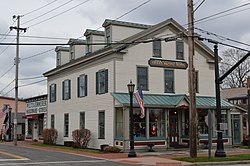
Grand Pacific Hotel downtown
|
|
 Location in Cuyahoga County and the state of Ohio. |
|
 Location of Ohio in the United States |
|
| Coordinates: 41°22′3″N 81°54′17″W / 41.36750°N 81.90472°WCoordinates: 41°22′3″N 81°54′17″W / 41.36750°N 81.90472°W | |
| Country | United States |
| State | Ohio |
| County | Cuyahoga |
| Government | |
| • Mayor | Ann Marie Donegan (D) |
| Area | |
| • Total | 4.12 sq mi (10.67 km2) |
| • Land | 4.12 sq mi (10.67 km2) |
| • Water | 0 sq mi (0 km2) |
| Elevation | 768 ft (234 m) |
| Population (2010) | |
| • Total | 9,024 |
| • Estimate (2012) | 8,936 |
| • Density | 2,190.3/sq mi (845.7/km2) |
| Time zone | Eastern (EST) (UTC-5) |
| • Summer (DST) | EDT (UTC-4) |
| ZIP codes | 44138 |
| Area code(s) | 440 |
| FIPS code | 39-58422 |
| GNIS feature ID | 1072238 |
| Website | Official website |
Olmsted Falls is a city in Cuyahoga County, Ohio, United States, and a southwestern suburb of Cleveland. The population was 9,024 at the 2010 census. The city’s main business district is located at the corners of Bagley and Columbia Roads, and contains the Grand Pacific Junction, a historic and pedestrian friendly shopping district.
Olmsted Falls is located at 41°22′3″N 81°54′17″W / 41.36750°N 81.90472°W (41.367626, -81.904818). According to the United States Census Bureau, the city has a total area of 4.12 square miles (10.67 km2), all land.
After the discovery of the New World, the land that became Olmsted Falls was originally part of the French colony of Canada (New France), which was ceded in 1763 to Great Britain and renamed Province of Quebec. In the late 18th century the land became part of the Connecticut Western Reserve in the Northwest Territory, then was purchased by the Connecticut Land Company in 1795.
In 1806, the vast tract of land comprising present-day Olmsted Falls, North Olmsted, and Olmsted Township was purchased for $30,000 by Aaron Olmsted, a wealthy sea captain.
...
Wikipedia
