Okidaitōjima
| Native name: 沖大東島 Okidaitō-jima |
|
|---|---|

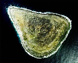
Aerial Photograph of Okidaitōjima
|
|
| Geography | |
| Location | Philippine Sea |
| Coordinates | 24°28′N 131°11′E / 24.467°N 131.183°E |
| Archipelago | Daitō Islands |
| Area | 1.19 km2 (0.46 sq mi) |
| Length | 1.5 km (0.93 mi) |
| Width | 1 km (0.6 mi) |
| Coastline | 4.5 km (2.8 mi) |
| Highest elevation | 31.1 m (102 ft) |
| Administration | |
|
Japan
|
|
| Prefectures | Okinawa Prefecture |
| District | Shimajiri District |
| Village | Kitadaitō |
| Demographics | |
| Population | -uninhabited- |
Okidaitōjima (沖大東島?), also spelled as Oki Daitō Island or Oki-Daitō or Oki-no-Daitō, previously known as Rasa Island (ラサ島 Rasa-tō?), is an abandoned island in the Daitō Islands group southeast of Okinawa, Japan. It is administered as part of the village of Kitadaitō, Shimajiri District, Okinawa.
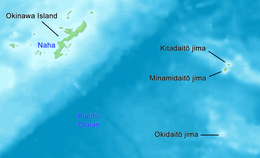
Okidaitōjima is a relatively isolated coralline island, located approximately 110 kilometres (59 nmi) south of Minamidaitōjima, the latest island of the archipelago, and 160 kilometres (86 nmi) south of Kitadaitōjima. Naha, Okinawa is 408 kilometres (220 nmi) to the northwest. As with the other islands in the archipelago, Okidaitōjima is an uplifted coral atoll with a steep coastal cliff of limestone (the former fringing coral reef of the island), and a depressed center (the former lagoon of the island). The island is roughly triangular in shape, with a circumference of about 4.5 kilometres (2.8 mi) and an area of 1.15 square kilometres (0.44 sq mi). The highest point is 33 metres (108 ft) above sea level. Due to extensive phosphate mining operations in the early 20th century, and decades of use as a bombing and gunnery range by the United States Navy, the island has very little topsoil and no trees.
...
Wikipedia

