Oilton, Texas
| Oilton, Texas | |
|---|---|
| CDP | |
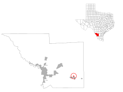
 Location of Oilton, Texas |
|
 |
|
| Coordinates: 27°28′8″N 98°58′33″W / 27.46889°N 98.97583°WCoordinates: 27°28′8″N 98°58′33″W / 27.46889°N 98.97583°W | |
| Country | United States |
| State | Texas |
| County | Webb |
| Established | 1922 |
| Area | |
| • Total | 1.4 sq mi (4 km2) |
| • Land | 1.4 sq mi (4 km2) |
| • Water | 0.0 sq mi (0 km2) |
| Elevation | 860 ft (262 m) |
| Population (2010) | |
| • Total | 152 |
| • Density | 110/sq mi (42/km2) |
| Time zone | CST (UTC-6) |
| • Summer (DST) | CST (UTC-5) |
| Zip Code | 78371 |
| Area code(s) | +1-361 |
| FIPS code | 48-53556 |
| GNIS feature ID | 1343096 |
| Nearest Airports: Laredo: Laredo International Airport KLRD LRD Nuevo Laredo: Quetzalcoatl International Airport MMNL NLD | |
Oilton is a census-designated place (CDP) in Webb County, Texas, United States. The population was 152 at the 2010 census. The community is within the boundary of Webb Consolidated Independent School District and is home to the Oilton Elementary School.
Oilton is located 32 miles east of Laredo, Texas. It was originally called Torrecillas Towers, for two limestone formations nearby. In 1922 the name was changed because that year, oil was discovered near the town, which also caused it to grow.
Oilton is located at 27°28′8″N 98°58′33″W / 27.46889°N 98.97583°W (27.468979, -98.975739).
According to the United States Census Bureau in 2000, the CDP has a total area of 0.8 square miles (2.2 km²), all of it land. This CDP gained area in the changes in Webb County prior to the 2010 census. Its total area was increased to 1.4 square miles (3.6 km2), all land.
As of the census of 2000, there were 310 people, 89 households, and 71 families residing in the CDP. The population density was 371.1 people per square mile (142.5/km²). There were 124 housing units at an average density of 148.4/sq mi (57.0/km²). The racial makeup of the CDP was 72.58% White, 1.61% African American, 20.65% from other races, and 5.16% from two or more races. Hispanic or Latino people of any race were 93.55% of the population.
...
Wikipedia
