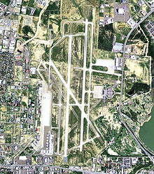
Laredo International Airport
| Laredo International Airport | |||||||||||||||||||
|---|---|---|---|---|---|---|---|---|---|---|---|---|---|---|---|---|---|---|---|
 |
|||||||||||||||||||

USGS aerial image, 2006
|
|||||||||||||||||||
| Summary | |||||||||||||||||||
| Airport type | Public | ||||||||||||||||||
| Owner | City of Laredo | ||||||||||||||||||
| Serves | Laredo, Texas | ||||||||||||||||||
| Elevation AMSL | 508 ft / 155 m | ||||||||||||||||||
| Coordinates | 27°32′38″N 99°27′42″W / 27.54389°N 99.46167°WCoordinates: 27°32′38″N 99°27′42″W / 27.54389°N 99.46167°W | ||||||||||||||||||
| Website | CityOfLaredo.com/... | ||||||||||||||||||
| Map | |||||||||||||||||||
| Location within Texas | |||||||||||||||||||
| Runways | |||||||||||||||||||
|
|||||||||||||||||||
| Statistics (2014) | |||||||||||||||||||
|
|||||||||||||||||||
|
Sources: airport website and FAA
|
|||||||||||||||||||
| Passengers | 116,565 |
|---|---|
| Flight operations | 57,744 |
Laredo International Airport (IATA: LRD, ICAO: KLRD, FAA LID: LRD) is a city-owned public-use airport located three nautical miles (6 km) northeast of the central business district of Laredo, a city in Webb County, Texas, United States.
The airport is served by three commercial airlines with flights to Houston, Dallas, Las Vegas and Orlando. In the twelve months ending December 2013, LRD had 102,856 passengers. In 2012, LRD totaled 460,000,612 pounds of cargo.
The Laredo International Airport was used by the United States Army Air Forces during World War II as Laredo Army Airfield, and by the United States Air Force as Laredo Air Force Base during the Cold War as a pilot training base with T-33 Shooting Star and later T-37 Tweet and T-38 Talon aircraft. The military presence ended in December 1973 as part of a nationwide defense cutback following the end of the Vietnam War.
...
Wikipedia

