Oak Forest
| Oak Forest, Illinois | ||
|---|---|---|
| City | ||
| City of Oak Forest, Illinois | ||

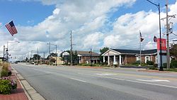
Cicero Avenue in Oak Forest
|
||
|
||
 Location in Cook County and the state of Illinois. |
||
 Location of Illinois in the United States |
||
| Coordinates: 41°36′27″N 87°45′2″W / 41.60750°N 87.75056°WCoordinates: 41°36′27″N 87°45′2″W / 41.60750°N 87.75056°W | ||
| Country | United States | |
| State | Illinois | |
| County | Cook | |
| Township | Bremen | |
| Incorporated | 1900 | |
| Government | ||
| • Type | Mayor-council | |
| • Mayor | Henry Kuspa | |
| Area | ||
| • Total | 6.00 sq mi (15.5 km2) | |
| • Land | 5.95 sq mi (15.4 km2) | |
| • Water | 0.05 sq mi (0.1 km2) 0.83% | |
| Population (2010) | ||
| • Total | 27,962 | |
| • Density | 4,699.5/sq mi (1,814.5/km2) | |
| Down 0.32% from 2000 | ||
| Standard of living (2009-11) | ||
| • Per capita income | $26,199 | |
| • Median home value | $216,200 | |
| ZIP code(s) | 60452 | |
| Area code(s) | 708 | |
| Geocode | 54638 | |
| Website | www |
|
Oak Forest is a suburban city about 24 miles (39 km) south-southwest of downtown Chicago in Bremen Township in Cook County, Illinois, United States. The population was 27,962 at the 2010 census.
The origins of present-day Oak Forest begins with a railroad whistle stop on the Chicago, Rock Island and Pacific Railroad near the present day intersection of 159th Street (US Route 6) and Cicero Avenue (Illinois Route 50) which primarily served area dairy farmers. This stop was located in a largely forested area of what was previously known as the Cooper's Grove Stand of Timber. By the 1880s this particular area of timber was being referred to as the "Oak Forest" due to its abundance of oak trees. A section of the former "Cooper's Grove Road" paralleling the railroad track from 66th Court to 167th Street in Tinley Park became known as "Oak Forest Avenue," because it was the road from the Village of Bremen/New Bremen (now Tinley Park) that lead to this "Oak Forest."
In 1907, Cook County approved construction of a second county poor farm and infirmary on a site generally at the southeast corner of 159th Street and Cicero Avenue to address overcrowding conditions at the County Poor Farm in Dunning on the northwest side of Chicago. This location was very near the Oak Forest railroad stop which provided convenient rail access to the facility. A railroad spur off of the Rock Island railroad line was also constructed onto the Oak Forest Hospital site that was used for both delivery of materials during its construction and delivery of coal for its heating plant and other goods used at the facility for many years. The Oak Forest Infirmary opened in 1910. Shortly after its opening, the facility accommodated close to 2,000 people suffering from poverty, mental illness, alcoholism, and other problems. The residents of the Infirmary helped maintain farmlands at and around the facility. By 1932, the Infirmary was serving more than 4,000 patients, including over 500 with tuberculosis.
...
Wikipedia

