Norwood, Ohio
| Norwood, Ohio | |||
|---|---|---|---|
| City | |||

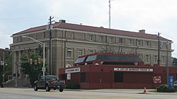
Norwood Police Department and Norwood Municipal Building on Montgomery Road
|
|||
|
|||
| Nickname(s): Gem of the Highlands | |||
 Location in Hamilton County and the state of Ohio. |
|||
| Coordinates: 39°9′36″N 84°27′18″W / 39.16000°N 84.45500°WCoordinates: 39°9′36″N 84°27′18″W / 39.16000°N 84.45500°W | |||
| Country | United States | ||
| State | Ohio | ||
| County | Hamilton | ||
| Government | |||
| • Mayor | Thomas Williams (D) | ||
| Area | |||
| • Total | 3.15 sq mi (8.16 km2) | ||
| • Land | 3.15 sq mi (8.16 km2) | ||
| • Water | 0 sq mi (0 km2) | ||
| Elevation | 656 ft (200 m) | ||
| Population (2010) | |||
| • Total | 19,207 | ||
| • Estimate (2012) | 19,086 | ||
| • Density | 6,097.5/sq mi (2,354.3/km2) | ||
| Time zone | Eastern (EST) (UTC−5) | ||
| • Summer (DST) | EDT (UTC−4) | ||
| ZIP codes | 45212, 45207 | ||
| Area code | 513 | ||
| FIPS code | 39-57386 | ||
| GNIS feature ID | 1056460 | ||
| Website | http://www.norwood-ohio.com/ | ||
Norwood is the second most populous city in Hamilton County, Ohio, United States, and an enclave of the larger city of Cincinnati. The population was 19,207 at the 2010 census. Originally settled as an early suburb of Cincinnati in the wooded countryside north of the city, the area is characterized by older homes and tree-lined streets.
The earliest humans in the area now known as Norwood are believed to have been Pre-Columbian era people of the Adena culture.Norwood Mound, a prehistoric earthwork mound built by the Adena, is located in Norwood and listed on the National Register of Historic Places. The Adena constructed the mound at the location of Norwood's present-day Water Tower Park, which is the highest land elevation in the city and one of the highest in all of Hamilton County. Archaeologists believe the mound was built at this site due to the high elevation and was used by the Adena for religious ceremonies and smoke signaling.
Native American mounds are not uncommon in Ohio and several were located in Downtown Cincinnati at the time of arrival of the first white settlers. However, by 1895, the Norwood Mound was the only remaining mound in the vicinity of Cincinnati." The mound has never been excavated, but it is reported that many artifacts found in the area by early Norwood settlers in the 1800s made up the original nucleus of the Native American Art Collection of the Cincinnati Art Museum. In the early-20th century, Norwood High School named their sports team mascot the Indians in honor of this local Native American heritage.
In 1787, the United States Congress established the Northwest Territory, and John Cleves Symmes, Congressman from New Jersey, purchased 311,682 acres (126,133 ha) of the territory (the Symmes Purchase), within which the future Norwood is located. One year later, the first permanent settlement on the banks of the Ohio River in what would later become Cincinnati was established. In 1793, General "Mad Anthony" Wayne led several companies of troops from Fort Washington in Cincinnati to advance against a hostile tribe of Native Americans encamped on the banks of the nearby Millcreek in what is now St. Bernard. Historians believe that a company of troops under the direction of General Wayne made their way through Norwood during this campaign and widened an old Native American trail, which followed the path of present-day Smith Road, Montgomery Road, and Carthage Avenue. In 1859, an early Norwood pioneer named Joseph G. Langdon claimed to have found a bullet buried in the heart of an oak tree on his Norwood property left by Anthony Wayne's troops 66 years earlier.
...
Wikipedia


