Northwest Branch Anacostia River
| Northwest Branch Anacostia River | |
| Country | United States |
|---|---|
| State | Maryland |
| Tributaries | |
| - left | Old Orchard, Bryants Nursery, Norwood, Rolling Stone |
| - right | Bachelors Forest, Longmeade, Bel Pre Creek, Wheaton Park, Lamberton Dr, Sligo Creek |
| Cities | Wheaton, Silver Spring, Hyattsville |
| Source | |
| - location | Sandy Spring, Maryland |
| Mouth | Anacostia River |
| - location | Bladensburg, MD |
| - coordinates | 38°56′34″N 76°56′39″W / 38.942832°N 76.944036°WCoordinates: 38°56′34″N 76°56′39″W / 38.942832°N 76.944036°W |
| Length | 21.5 mi (35 km) |
| Basin | 53.5 sq mi (139 km2) |
|
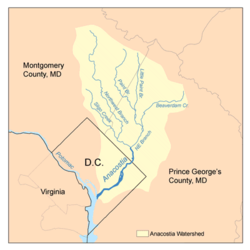
Map of the Anacostia River watershed showing the Northwest Branch
|
|
Northwest Branch Anacostia River is a 21.5-mile-long (34.6 km) free-flowing stream in Montgomery County and Prince George's County, Maryland. It is a tributary of the Anacostia River, which flows to the Potomac River and the Chesapeake Bay.
The headwaters of the Northwest Branch are located near the community of Sandy Spring. The stream flows southward for 21.5 miles (34.6 km) to its confluence with the Northeast Branch near Bladensburg to form the main stem of the Anacostia.
The watershed in Montgomery County includes portions of the communities of Norwood, Bel Pre Manor, Colesville, Layhill, Glenmont, Wheaton, Hillandale, White Oak, Silver Spring, Kemp Mill, Four Corners and Takoma Park. The Prince George's County portion of the watershed includes Adelphi, Langley Park, University Park, Chillum, Hyattsville, Avondale and Brentwood. The total watershed area, including a small portion of land in Washington, D.C., is 53.5 square miles (139 km2), with a resident population of about 254,000.
...
Wikipedia

