Sligo Creek
| Sligo Creek | |
| River | |
|
The creek running through Silver Spring, Maryland
|
|
| Country | United States |
|---|---|
| State | Maryland |
| Tributaries | |
| - left | Long Branch |
| - right | Wheaton Br, Comstock Br, Takoma Park Br |
| City | Silver Spring, Maryland |
| Source | |
| - location | Kemp Mill, Maryland |
| - elevation | 450 ft (137 m) |
| Mouth | Northwest Branch |
| - location | Hyattsville, Maryland |
| - elevation | 35 ft (11 m) |
| - coordinates | 38°57′32″N 76°58′26″W / 38.959°N 76.974°WCoordinates: 38°57′32″N 76°58′26″W / 38.959°N 76.974°W |
| Length | 9.1 mi (15 km) |
| Basin | 11.6 sq mi (30 km2) |
| Discharge | for Takoma Park |
| - average | 26 cu ft/s (1 m3/s) |
| - max | 49 cu ft/s (1 m3/s) |
| - min | 3.3 cu ft/s (0 m3/s) |
|
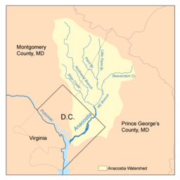
Map of the Anacostia River watershed showing Sligo Creek
|
|
Sligo Creek is a free-flowing tributary of the Northwest Branch of the Anacostia River in Maryland. (The Anacostia, in turn, feeds into the Potomac River and eventually empties into the Atlantic Ocean via Chesapeake Bay.) The creek is approximately 9.1 miles (14.6 km) long, with a drainage area of about 11.6 square miles (30 km2). It also inspired Katherine Paterson to write the Newbery Medal award winning book Bridge to Terabithia.
The creek rises in the Kemp Mill section of Silver Spring in Montgomery County and joins with Northwest Branch near the city of Hyattsville in Prince George's County. The lower portion of the creek has been channelized. Elevations in the subwatershed range from 450 feet (137 m) above sea level to 35 feet (11 m) at the confluence with Northwest Branch; the average gradient for the course of the creek is 0.72%.
Contributing streams that flow into the creek include Wheaton Branch, Comstock Branch, Takoma Park Branch, and Long Branch.
Sligo Creek is one of the most heavily urbanized subwatersheds in the Anacostia watershed, with a population density of 7,081 people per mi2. 75% of the watershed is in Montgomery County, 20% is in Prince George's County, and 5% is in the District of Columbia. Less than 15% of the subwatershed is undeveloped, and only 10% is forested. Less than 0.01% of the area is wetlands.
...
Wikipedia


