Silver Spring, Maryland
| Silver Spring, Maryland | |
|---|---|
| Census-designated place | |

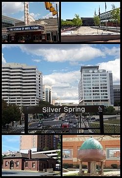
Clockwise from top: AFI Silver, Veteran's Plaza and the civic building, Downtown Silver Spring from the Metro station, Acorn Park, Baltimore and Ohio Railroad Station
|
|
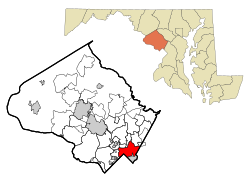
 Location of Silver Spring, Maryland |
|
| Coordinates: 39°0′15″N 77°1′8″W / 39.00417°N 77.01889°W | |
| Country | United States |
| State | Maryland |
| County | Montgomery |
| Area | |
| • Total | 7.92 sq mi (20.5 km2) |
| • Land | 7.92 sq mi (20.5 km2) |
| • Water | 0.0 sq mi (0.0 km2) |
| Elevation | 341 ft (104 m) |
| Population (2013) | |
| • Total | 76,716 |
| • Density | 9,022.9/sq mi (3,483.8/km2) |
| Time zone | Eastern (EST) (UTC-5) |
| • Summer (DST) | EDT (UTC-4) |
| ZIP codes | 20901, 20902, 20903, 20904, 20905, 20906, 20910 |
| Area code(s) | 301, 240 |
| FIPS code | 24-72450 |
| GNIS feature ID | 0591290 |
| Highways | I-495, US 29, MD 97, MD 193, MD 390, MD 410 |
Silver Spring is an unincorporated community and census-designated place (CDP) in Montgomery County, Maryland, United States. It had a population of 76,716 according to 2013 estimates by the United States Census Bureau, making it the fourth most populous place in Maryland, after Baltimore, Columbia, and Germantown.
The urbanized, oldest, and southernmost part of Silver Spring is a major business hub that lies at the north apex of Washington, D.C. As of 2004, the Central Business District (CBD) held 7,254,729 square feet (673,986 m2) of office space, 5216 dwelling units and 17.6 acres (71,000 m2) of parkland. The population density of this CBD area of Silver Spring was 15,600 per square mile all within 360 acres (1.5 km2) and approximately 2.5 square miles (6 km2) in the CBD/downtown area. The community has recently undergone a significant renaissance, with the addition of major retail, residential, and office developments.
Silver Spring takes its name from a mica-flecked spring discovered there in 1840 by Francis Preston Blair, who subsequently bought much of the surrounding land. Acorn Park, tucked away in an area of south Silver Spring away from the main downtown area, is believed to be the site of the original spring.
As an unincorporated area, Silver Spring's boundaries are not officially defined. As of the 2010 Census the United States Census Bureau defines Silver Spring as a census-designated place with a total area of 7.92 square miles (20.5 km2), all land; however, it does contain numerous creeks and small lakes. This definition is a 15% reduction from the 9.4 sq. mi. used in previous years. The United States Geological Survey locates the center of Silver Spring at 38°59′26″N 77°1′35″W / 38.99056°N 77.02639°W, notably some distance from the Census Bureau's datum. By another definition, Silver Spring is located at 39°0′15″N 77°1′8″W / 39.00417°N 77.01889°W (39.004242, -77.019004). The definitions used by the Silver Spring Urban Planning District, the United States Postal Service, the Greater Silver Spring Chamber of Commerce, etc., are all different, each defining it for its own purposes.
...
Wikipedia
