Colesville, Maryland
| Colesville, Maryland | |
|---|---|
| Census-designated place | |
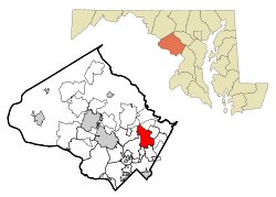
 Location of Colesville, Maryland |
|
| Coordinates: 39°4′47″N 77°0′12″W / 39.07972°N 77.00333°WCoordinates: 39°4′47″N 77°0′12″W / 39.07972°N 77.00333°W | |
| Country | |
| State |
|
| County |
|
| Area | |
| • Total | 9.2 sq mi (23.9 km2) |
| • Land | 9.2 sq mi (23.9 km2) |
| • Water | 0.0 sq mi (0.0 km2) |
| Elevation | 436 ft (133 m) |
| Population (2000) | |
| • Total | 19,810 |
| • Density | 2,144.4/sq mi (828.0/km2) |
| Time zone | Eastern (EST) (UTC-5) |
| • Summer (DST) | EDT (UTC-4) |
| ZIP codes | 20904, 20905, 20914 |
| Area code(s) | 301, 240 |
| FIPS code | 24-18475 |
| GNIS feature ID | 0589998 |
Colesville is a census-designated place and an unincorporated area in Montgomery County, Maryland, in the United States.
As an unincorporated area, Colesville's boundaries are not officially defined. In fact, many residents consider the town to be one of the many neighborhoods of Silver Spring, Maryland. Colesville is recognized by the United States Postal Service as an acceptable city name in two northeastern Montgomery County ZIP codes, with Silver Spring being the preferred city name. It is also recognized by the United States Census Bureau as a census-designated place, and by the United States Geological Survey as a populated place located at 39°4′47″N 77°0′12″W / 39.07972°N 77.00333°W (39.079695, -77.003263).
According to the United States Census Bureau, the place has a total area of 9.2 square miles (24 km2), all of it land.
Colesville's generally accepted boundaries extend between the Northwest and Paint Branches of the Anacostia River. Its northern and southern boundaries are not as well-defined, but are usually assumed to run from Springbrook High School in the south to Cloverly in the north.
...
Wikipedia
