North Fork Shenandoah River
| Shenandoah River | |
|
Crossing the Shenandoah River in Harpers Ferry, West Virginia
|
|
| Country | United States |
|---|---|
| States | Virginia, West Virginia |
| Tributaries | |
| - left | North Fork |
| - right | South Fork |
| Towns | Harper's Ferry, WV, Front Royal, VA, Luray, VA |
| Primary source | North Fork |
| - location | Shenandoah Mountain |
| Secondary source | South Fork |
| - location | Port Republic |
| Source confluence | |
| - location | Front Royal, VA |
| Mouth | Potomac River |
| - location | Harpers Ferry |
| - elevation | 250 ft (76 m) |
| - coordinates | 39°19′21″N 77°43′40″W / 39.3225°N 77.727778°WCoordinates: 39°19′21″N 77°43′40″W / 39.3225°N 77.727778°W |
| Length | 56 mi (90 km) |
| Basin | 2,937 sq mi (7,607 km2) |
| Discharge | for Millville, WV |
| - average | 2,755 cu ft/s (78 m3/s) |
|
Shenandoah River Watershed
|
|
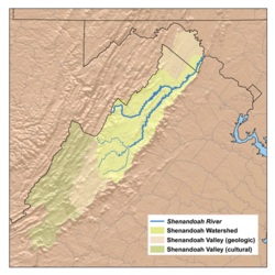
The Shenandoah River /ˌʃɛnənˈdoʊə/ is a tributary of the Potomac River, 55.6 miles (89.5 km) long with two forks approximately 100 miles (160 km) long each, in the U.S. states of Virginia and West Virginia. The principal tributary of the Potomac, the river and its tributaries drain the central and lower Shenandoah Valley and the Page Valley in the Appalachians on the west side of the Blue Ridge Mountains, in northwestern Virginia and the Eastern Panhandle of West Virginia.
The Shenandoah River is formed northeast of Front Royal near Riverton, by the confluence of the South Fork and the North Fork. It flows northeast across Warren County, passing underneath Interstate 66 1 mile (1.6 km) from its formation. Beyond the I-66 bridge the river flows through a set of bends before turning to the northeast again, crossing into Clarke County 11 miles (18 km) below I-66. Five miles (8 km) downriver from the Clarke County border, the Shenandoah passes under U.S. Route 50 and then passes through a triple bend. 14.5 miles (23.3 km) below the Route 50 bridge, the river passes underneath State Route 7 and then continues northeast another 8 miles (13 km) where it crosses into Jefferson County in West Virginia, in the extreme eastern tip of the state. Once in West Virginia the river completes six large bends before joining with the Potomac from the south near Harpers Ferry, 20 miles (32 km) from the Virginia-West Virginia border.
...
Wikipedia


