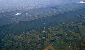
Shenandoah Valley
| Shenandoah Valley | |
|---|---|
 |
|
| Location | Virginia, Eastern Panhandle of West Virginia |
| Floor elevation | 500 feet (150 m)-1,500 feet (460 m) |
| Long-axis direction | Northeast to southwest |
| Geography | |
| Bounded by |
Blue Ridge Mountains (east) Ridge and Valley Appalachians (west) Potomac River (north) James River (south) |
| Population centers |
Winchester Harrisonburg Staunton Lexington Martinsburg, West Virginia |
| Traversed by |
|
The Shenandoah Valley /ˌʃɛnənˈdoʊə/ is a geographic valley and cultural region of western Virginia and the Eastern Panhandle of West Virginia in the United States. The valley is bounded to the east by the Blue Ridge Mountains, to the west by the eastern front of the Ridge-and-Valley Appalachians (excluding Massanutten Mountain), to the north by the Potomac River and to the south by the James River. The cultural region covers a larger area that includes all of the valley plus the Virginia highlands to the west, and the Roanoke Valley to the south. It is physiographically located within the Ridge and Valley province and is a portion of the Great Appalachian Valley.
Named for the river that stretches much of its length, the Shenandoah Valley encompasses eight counties in Virginia and two counties in West Virginia.
The cultural region includes five more counties in Virginia:
Between the Roanoke Valley in the south and Harpers Ferry in the north, where the Shenandoah River joins the Potomac, the Valley cultural region contains 10 independent cities:
...
Wikipedia
