James River
| James River | |
|
James River at the crossing of the Blue Ridge Parkway
|
|
| Name origin: King James I | |
| Country | United States |
|---|---|
| State | Virginia |
| Tributaries | |
| - left | Chickahominy River |
| - right | Appomattox River |
| Source | Confluence of Cowpasture River and Jackson River |
| - location | Allegheny Mountains, Virginia |
| - coordinates | 37°47′4″N 79°46′33″W / 37.78444°N 79.77583°W |
| Mouth | Hampton Roads |
| - location | Chesapeake Bay, Virginia |
| - coordinates | 36°56′30″N 76°26′37″W / 36.94167°N 76.44361°WCoordinates: 36°56′30″N 76°26′37″W / 36.94167°N 76.44361°W |
| Length | 348 mi (560 km) |
| Basin | 10,432 sq mi (27,019 km2) |
| Discharge | |
| - average | 6,835 cu ft/s (194 m3/s) |
| - max | 313,000 cu ft/s (8,863 m3/s) |
| - min | 10 cu ft/s (0 m3/s) |
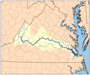
The James River is a river in the U.S. state of Virginia. It is 348 miles (560 km) long, extending to 444 miles (715 km) if one includes the Jackson River, the longer of its two source tributaries. The James River drains a catchment comprising 10,432 square miles (27,020 km2). The watershed includes about 4% open water and an area with a population of 2.5 million people (2000). It is the 12th longest river in the United States that remains entirely within a single state.
The James River forms in the Appalachian Mountains, near Iron Gate on the border between Alleghany and Botetourt counties, from the confluence of the Cowpasture and Jackson rivers, and flows into the Chesapeake Bay at Hampton Roads. Tidal waters extend west to Richmond, the capital of Virginia, at the river's fall line (the head of navigation). Larger tributaries draining to the tidal portion include the Appomattox River, Chickahominy River, Warwick River, Pagan River, and the Nansemond River.
At its mouth near Newport News Point, the Elizabeth River and the Nansemond River join the James River to form the harbor area known as Hampton Roads. Between the tip of the Virginia Peninsula near Old Point Comfort and the Willoughby Spit area of Norfolk in South Hampton Roads, a channel leads from Hampton Roads into the southern portion of the Chesapeake Bay and out to the Atlantic Ocean a few miles further east. Many boats pass through this river to import and export Virginia products.
...
Wikipedia


