North Conway
| North Conway, New Hampshire | |
|---|---|
| Census-designated place | |

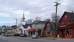
Buildings in downtown North Conway
|
|
| Coordinates: 44°3′11″N 71°7′41″W / 44.05306°N 71.12806°WCoordinates: 44°3′11″N 71°7′41″W / 44.05306°N 71.12806°W | |
| Country | United States |
| State | New Hampshire |
| County | Carroll |
| Town | Conway |
| Area | |
| • Total | 4.3 sq mi (11.2 km2) |
| • Land | 4.3 sq mi (11.1 km2) |
| • Water | 0.04 sq mi (0.1 km2) |
| Elevation | 525 ft (160 m) |
| Population (2010) | |
| • Total | 2,349 |
| • Density | 549/sq mi (211.9/km2) |
| Time zone | Eastern (EST) (UTC-5) |
| • Summer (DST) | EDT (UTC-4) |
| ZIP code | 03860 |
| Area code(s) | 603 |
| FIPS code | 33-53860 |
| GNIS feature ID | 0872395 |
North Conway is a census-designated place (CDP) and village in eastern Carroll County, New Hampshire, United States. The population was 2,349 at the 2010 census. A year-round resort area, North Conway is the largest village within the town of Conway, which is bounded on the east by the Maine state line. The White Mountain National Forest is to the west and north. Conway is home to Cathedral Ledge (popular with climbers), Echo Lake State Park, and Mount Cranmore. North Conway is known for its large number of outlet shops.
Chartered in 1765 by Colonial Governor Benning Wentworth, the town is named for Henry Seymour Conway, ambitious son of a prominent English family, who was elected to the House of Commons at age 20, fought at Culloden, and became Secretary of State. Early settlers called the area Pequawket (known colloquially as Pigwacket), adopting the name of the Abenaki Indian village which stretched down the Saco River to its center at Fryeburg, Maine.
...
Wikipedia


