Niah National Park
| Niah Caves | |
|---|---|

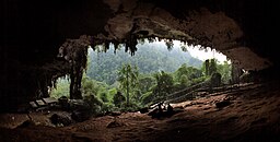
The main entrance to the Niah Caves at sunset.
|
|
| Coordinates | 3°48′50″N 113°46′53″E / 3.81389°N 113.78139°ECoordinates: 3°48′50″N 113°46′53″E / 3.81389°N 113.78139°E |
| Discovery | 1950 |
| Entrances | 1 |
Niah National Park, located within Miri Division, Sarawak, Malaysia, is the site of the Niah Caves limestone cave and archeological site. Niah National Park was 31.4 km² when it was gazetted in 1974. Nomination for World Heritage status of the Niah Caves was sent to UNESCO in 2010.
The caves are thought to have been visited by Europeans in search of minerals, perhaps in the late 1840s, but no documentation is known. Alfred Russel Wallace is said to have learned about the caves during his 1855 expedition to (then much smaller) Sarawak: if so it was from his host at the Simunjan coal mine, Robert Coulson, who had worked in Labuan and explored its adjacent areas. Wallace subsequently recommended to Charles Darwin and the Royal Society that Coulson be appointed to explore the caves of Borneo as a potential site for discovering important hominid fossils; however, Alfred Hart Everett was chosen.
In the 1950s and 1960s, Barbara and Tom Harrisson excavated the site and made significant discoveries. They discovered the Deep Skull in 1958.
Since then local universities and foreign scientists have continued the archaeological research, and many articles have been published in the Sarawak Museum Journal. The site has been re-excavated (1999–2003+) by The Niah Caves Project (NCP), a joint British-Malaysian expedition, to determine the accuracy of Harrisson's work.
The main cave, Niah Great Cave, is located in Gunung Subis and is made up of several voluminous chambers with high ceilings. The Great Cave lies in a large limestone block, about a kilometre long in general north to south direction and about half a kilometre wide, that is detached from the main Gunung Subis complex, by a valley between about 150 to 200 meters wide. The main Gunung Subis complex rises to about 394 meters above sea level at its highest point. The whole "Gunung Subis Limestone Complex" lies some 17 kilometres inland from the South China Sea coast, near the town of Batu Niah and about 65 kilometres south west of the town Miri. It is roughly heart shaped measuring five kilometres from its northern tip to the south and four kilometres across. The Gunung Subis is surrounded by a low countryside with gentle hills from which the small limestone massif and its smaller detached blocks rise rather abruptly out of the jungle, some with cliffs over 100 metres high. Though it is not an extensive cave system compared to others in Sarawak, it has been estimated to cover some 10 hectares and the roof rises to about 75 metres above the cave floor in some places. In geological terms, the limestones are part of the Subis Formation. This is dated to some 20 to 16 million years ago during the Early Miocene.
...
Wikipedia


