New York State Route 3
| New York State Route 3 | ||||
|---|---|---|---|---|

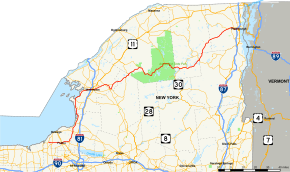
Map of northern New York with NY 3 highlighted in red
|
||||
| Route information | ||||
| Maintained by NYSDOT and the cities of Watertown and Plattsburgh | ||||
| Length: | 245.88 mi (395.71 km) | |||
| Existed: | 1924 – present | |||
| Major junctions | ||||
| West end: |
|
|||
|
|
||||
| East end: |
|
|||
| Location | ||||
| Counties: | Cayuga, Oswego, Jefferson, Lewis, St. Lawrence, Essex, Franklin, Clinton | |||
| Highway system | ||||
|
||||
New York State Route 3 (NY 3) is a major east–west state highway in New York, in the United States, that connects central New York to the North Country region near the Canada–US border via Adirondack Park. The route extends for 245.88 miles (395.71 km) between its western terminus at an intersection with NY 104A in the Cayuga County town of Sterling and its eastern terminus at a junction with U.S. Route 9 (US 9) in the Clinton County city of Plattsburgh. NY 3 traverses eight counties and is a lakeside roadway from Mexico to Sackets Harbor, a mountainous route in Adirondack Park, and an urban arterial in Fulton, Watertown, and Plattsburgh.
In 1924, the segment of the Theodore Roosevelt International Highway within New York was designated NY 3. At that time, it spanned the full east–west length of the state, extending from the eastern bank of the Niagara River in North Tonawanda to the western edge of Lake Champlain in Plattsburgh; however, the routing through the North Country was significantly different at that time from its modern alignment. The route was moved onto its modern routing east of Watertown as part of the 1930 renumbering of state highways in New York; it was truncated to Sterling on its western end and rerouted to follow its current alignment from Sterling to Watertown roughly five years later.
...
Wikipedia

