New York State Route 25 Truck
| New York State Route 25 | ||||
|---|---|---|---|---|

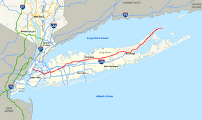
Map of Long Island with NY 25 highlighted in red
|
||||
| Route information | ||||
| Maintained by NYSDOT, NYCDOT and the village of Greenport | ||||
| Length: | 105.07 mi (169.09 km) | |||
| Existed: | mid-1920s – present | |||
| Major junctions | ||||
| West end: | Second Avenue in Manhattan | |||
|
|
||||
| East end: |
|
|||
| Location | ||||
| Counties: | New York, Queens, Nassau, Suffolk | |||
| Highway system | ||||
|
||||
|
New York State Route 25 Truck |
|
|---|---|
| Location: | Laurel–Greenport |
New York State Route 25 (NY 25) is an east–west state highway in downstate New York in the United States. The route extends for just over 105 miles (169 km) from east midtown Manhattan in New York City to the Cross Sound Ferry terminal at Orient Point on the end of Long Island's North Fork. NY 25 is carried from Manhattan to Queens by way of the double-decked Queensboro Bridge over the East River.
NY 25 is unique among NYS routes (not counting interstates) on Long Island as it is the only one to leave the island (defined geographically), albeit minimally; it ends at the western terminus of the Queensborough Bridge. Not only does it terminate in Manhattan at its west end, but in a sense it also offers an egress from the island at its east end in the form of the ferry terminal (though the ferry is not a part of the route.) However, NY 25 does have something in common with other routes on Long Island. Both termini are without connections to other routes. Several other of the region's routes (for example NY 27, NY 101, NY 106, NY 107, and NY 110) have similar "dead" ends at one or both termini.
NY 25 has many names. In the borough of Queens, it is called Queens Boulevard, Hillside Avenue and finally Braddock Avenue. Braddock Avenue ends immediately upon crossing over the Cross Island Parkway. At that point, NY 25 turns east onto Jericho Turnpike, which runs along the Queens-Nassau border from Braddock Avenue to 257th street. Continuing east through Nassau and western Suffolk counties, NY 25 retains the name Jericho Turnpike. Further east, the highway becomes Main Street in Smithtown, Middle Country Road in central Suffolk, Main Street again in Riverhead, and finally Main Road in eastern Suffolk.
...
Wikipedia

