Calverton, New York
| Calverton, New York | |
|---|---|
| Hamlet and census-designated place | |

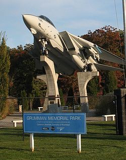
Grumman Memorial Park
|
|
 |
|
| Coordinates: 40°55′14″N 72°44′11″W / 40.92056°N 72.73639°WCoordinates: 40°55′14″N 72°44′11″W / 40.92056°N 72.73639°W | |
| Country | United States |
| State | New York |
| County | Suffolk |
| Area | |
| • Total | 28.5 sq mi (73.9 km2) |
| • Land | 28.0 sq mi (72.5 km2) |
| • Water | 0.5 sq mi (1.3 km2) |
| Elevation | 30 ft (9 m) |
| Population (2010) | |
| • Total | 6,510 |
| • Density | 230/sq mi (88/km2) |
| Time zone | Eastern (EST) (UTC-5) |
| • Summer (DST) | EDT (UTC-4) |
| ZIP code | 11933 |
| Area code(s) | 631 |
| FIPS code | 36-11781 |
| GNIS feature ID | 0945505 |
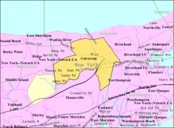
Calverton is a hamlet and census-designated place (CDP) in Suffolk County, New York, United States. The population was 6,510 at the 2010 census.
Most of Calverton is in the Town of Riverhead, while the area south of the Peconic River is a mostly undeveloped smaller portion in the Town of Brookhaven.
Calverton was first referred to as "Baiting Hollow Station" when the Long Island Rail Road arrived in 1844. The station closed in 1958, but the sheltered shed for the station remained standing as of 2007.
The area's Native American name was Conungum or Kanungum, meaning "fixed line" or "boundary". In 1868 the Calverton post office opened, named for Bernard J. Calvert. It remained a small farming community specializing in cranberries which grew in swampy areas along the Peconic River until the Navy purchase.
Calverton's history is tied closely to Naval Weapons Industrial Reserve Plant, Calverton. The United States Navy purchased 6,000 acres (24 km2) around Calverton from a local farmer named Harry Edwards in 1953, including the mansion of a grandson of F.W. Woolworth, so that Grumman could test and finish jets. A 10,000-foot (3,000 m) runway was built, and most of Grumman's F-14 Tomcat and E-2C Hawkeye aircraft were to pass through the plant.
In 1965 Nelson Rockefeller proposed using the base as the fourth major airport for the New York metropolitan area. Grumman and local opposition ended the quest. In 1978 more than 1,000 acres (4.0 km2) of the base was used to create Calverton National Cemetery, which is the largest and busiest (in terms of burials per day) United States national cemetery. In 1995, after Northrop acquired Grumman, the new Northrop Grumman pulled out of the base and the Navy began liquidating the land. In 1996 before the base could be turned over the Town of Riverhead, the base was used to reassemble the wreckage of TWA Flight 800 which had crashed about 20 miles (32 km) south in the ocean. In 2000 Skydive Long Island (formerly located at East Moriches) moved to the airport, and to this day continues to generate the majority of the current air traffic as a key destination for New York-based skydivers.
...
Wikipedia

