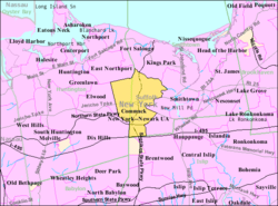
Commack, New York
| Commack, New York | |
|---|---|
| Hamlet and census designated place | |
 U.S. Census map |
|
| Location within the state of New York | |
| Coordinates: 40°50′42″N 73°17′0″W / 40.84500°N 73.28333°WCoordinates: 40°50′42″N 73°17′0″W / 40.84500°N 73.28333°W | |
| Country |
|
| State |
|
| County | Suffolk |
| Town | Smithtown and Huntington |
| Area | |
| • Total | 31.0 km2 (12.0 sq mi) |
| • Land | 31.0 km2 (12.0 sq mi) |
| • Water | 0.0 km2 (0.0 sq mi) |
| Elevation | 40 m (131 ft) |
| Population (2010) | |
| • Total | 36,124 |
| • Density | 1,200/km2 (3,000/sq mi) |
| Time zone | Eastern (EST) (UTC-5) |
| • Summer (DST) | EDT (UTC-4) |
| ZIP code | 11725 |
| Area code(s) | 631 |
| FIPS code | 36-17530 |
| GNIS feature ID | 0947221 |
Commack /kɑːmæk/ is a census designated place (CDP) that roughly corresponds to the hamlet by the same name in the towns of Huntington and Smithtown in Suffolk County, New York, United States on Long Island. The CDP's population was 36,124 at the 2010 census.
According to the United States Census Bureau, the CDP has a total area of 12.0 square miles (31.0 km2), all land.
The name "Commack" comes from the Secatogue Native Americans who lived on the South Shore of Long Island between Copiague and Bayport. The Secatogue named their northern lands in the center of the island Winnecomac, meaning "pleasant lands". This is what they must have thought when they looked over this area of flat lands with rich soil, and thick oak forests abounding with plants and wildlife. From its earliest days, Commack was known for its fertile soil, abundance of game, and wood.
Today all of Commack is settled and suburbanized and, like most unincorporated areas of Long Island, does not have a true, walkable downtown or "Main Street". The community is served by four major thoroughfares: the Long Island Expressway, the Northern State Parkway, the Sunken Meadow State Parkway and the at-grade Jericho Turnpike. It also includes the historic Long Island Motor Parkway, which itself included the spur to NY 25 that later became Harned Road.
...
Wikipedia

