Natanz
|
Natanz نطنز |
|
|---|---|
| city | |

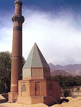
Tomb of Abd al Samad, built in 1304.
|
|
| Coordinates: 33°30′48″N 51°54′59″E / 33.51333°N 51.91639°ECoordinates: 33°30′48″N 51°54′59″E / 33.51333°N 51.91639°E | |
| Country |
|
| Province | Isfahan |
| County | Natanz |
| Bakhsh | Central |
| Population (2006) | |
| • Total | 12,060 |
| Time zone | IRST (UTC+3:30) |
| • Summer (DST) | IRDT (UTC+4:30) |
Natanz (Persian: نطنز, also romanized as Naţanz) is a city in and the capital of Natanz County, Isfahan Province, Iran. At the 2006 census, its population was 12,060, in 3,411 families. It is located 70 kilometres (43 mi) south-east of Kashan.
Its bracing climate and locally produced fruit are well known in Iran. Its pear fruits are well known. The famous Karkas mountain chain (Kuh-e Karkas) (meaning mountain of vultures), at an elevation of 3,899 meters, rises above the town, and locals point in its direction telling how the Achaemenian King, Darius III, was killed nearby.
Various small shrines dot the area, and it is known as the shrine of Abd as-Samad. The elements in the present complex date from 1304 with subsequent additions and restorations, such as the Khaneqah and Muqarnas vault. The tomb honors the Sufi Sheikh Abd al-Samad, and was built by the Sheikh's disciple, the Ilkhanid vizier Zain al-Din Mastari.
The Natanz Nuclear Facility, located some 30 km NNW from the town (33°43′N 51°43′E / 33.717°N 51.717°E) near a major highway, is generally recognized as Iran's central facility for enrichment with over 19,000 centrifuges currently operational and nearly half of them being fed with uranium hexafluoride.
...
Wikipedia

