Narmeln
| Narmeln (in English) Narmeln, Polski (German) |
|
|---|---|
| - Abandoned village - (abolished) |
|
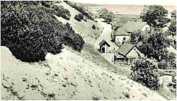
 View of Narmeln (before 1930) |
|
 Location of Kaliningrad Oblast in Russia |
|
|
|
|
|
|
|
| Administrative status | |
| Country | Russia |
| Federal subject | Kaliningrad Oblast |
| Administrative district | Baltiysky District |
| Statistics | |
| Area | 0.6 km2 (0.23 sq mi) |
| Population (1970 est.) | 0 inhabitants |
| Time zone | USZ1 (UTC+02:00) |
| Coaching inn | 1489 |
| Previous names |
Ermelen (until 1489), Narmeln (until 1945), Polski (until 1945) |
| Abolished | 1945 |
Narmeln (Russian: Нармельн, Polish: Polski), alternatively known as Polski, is an abandoned village in Baltiysky District of Kaliningrad Oblast, Russia. It is located on the Vistula Spit, on the border with Poland, the westernmost point of Russia.
Narmeln is distinct as it is one of the few places in Kaliningrad Oblast whose German name was not officially changed when the territory was annexed to the Soviet Union following World War II, and is also the only part of West Prussia to be annexed by the Soviet Union by the Treaty of Potsdam. Narmeln was depopulated after the war, and the Soviet side of the Vistula Spit was made into an exclusion zone, which remains in effect today.
Narmeln is located about 35 kilometres (22 miles) south-west of Baltiysk. The westernmost point of Russia is located on the Poland–Russia border nearby. (54°27′29.4″N 19°38′21″E / 54.458167°N 19.63917°E)
...
Wikipedia

