Baltiysky District, Kaliningrad Oblast
| Baltiysky District Балтийский район (Russian) |
|
|---|---|
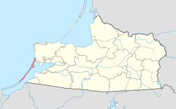
 Location of Baltiysky District in Kaliningrad Oblast |
|
| Coordinates: 54°39′N 19°55′E / 54.650°N 19.917°ECoordinates: 54°39′N 19°55′E / 54.650°N 19.917°E | |
 Vistula Spit, Baltiysky District |
|
| Location | |
| Country | Russia |
| Federal subject | Kaliningrad Oblast |
| Administrative structure (as of November 2011) | |
| Administrative center | town of Baltiysk |
| Administrative divisions: | |
| Towns of district significance | 2 |
| Rural okrugs | 1 |
| Inhabited localities: | |
| Cities/towns | 2 |
| Rural localities | 10 |
| Municipal structure (as of July 2009) | |
| Municipally incorporated as | Baltiysky Municipal District |
| Municipal divisions: | |
| Urban settlements | 2 |
| Rural settlements | 1 |
| Statistics | |
| Area | 101 km2 (39 sq mi) |
| Population (2010 Census) | 36,047 inhabitants |
| • Urban | 96.1% |
| • Rural | 3.9% |
| Density | 356.9/km2 (924/sq mi) |
| Time zone | USZ1 (UTC+02:00) |
| Official website | |
| on | |
Baltiysky District (Russian: Балти́йский райо́н) is an administrative district (raion), one of the fifteen in Kaliningrad Oblast, Russia. As a municipal division, it is incorporated as Baltiysky Municipal District. It is located in the west of the oblast. The area of the district is 101 square kilometers (39 sq mi). Its administrative center is the town of Baltiysk. Population: 36,047 (2010 Census). The population of Baltiysk accounts for 90.7% of the district's total population.
...
Wikipedia
