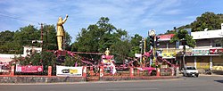
Nalgonda
|
Nalgonda నల్లగొండ نلگنڈہ Nilagiri, nalakonda Nallagonda |
|
|---|---|
| City | |

Clock Tower in Nalgonda
|
|
| Location in Telangana, India | |
| Coordinates: 17°03′N 79°16′E / 17.05°N 79.27°ECoordinates: 17°03′N 79°16′E / 17.05°N 79.27°E | |
| Country | India |
| State | Telangana |
| District | Nalgonda |
| Government | |
| • Type | Mayor–council |
| • Body | Nalgonda Municipality |
| • MLA | Komatireddy Venkat Reddy |
| • MP | Gutha Sukender Reddy |
| Area | |
| • Total | 105 km2 (41 sq mi) |
| Elevation | 421 m (1,381 ft) |
| Population (2011) | |
| • Total | 154,326 |
| • Density | 1,500/km2 (3,800/sq mi) |
| Languages | |
| • Official | Telugu, Urdu |
| Time zone | IST (UTC+5:30) |
| Telephone code | +91–8682 |
| Vehicle registration | TS–05 |
| Website | Nalgonda municipality |
Nalgonda (![]() pronunciation ) is a city and municipality in the Indian state of Telangana. It is the headquarters of the homonymous district, as well as the headquarters of the Nalgonda mandal in the Nalgonda revenue division.
pronunciation ) is a city and municipality in the Indian state of Telangana. It is the headquarters of the homonymous district, as well as the headquarters of the Nalgonda mandal in the Nalgonda revenue division.
The city's name is derived from two Telugu words: nalla ("black") and konda ("hill"). In the past, Nalgonda was referred to as Nilagiri. During the medieval Bahamani kingdom, it was renamed Nallagonda. The name was changed to "Nalgonda" for official uses during the rule of the later Nizam kings.
There is archaeological evidence that Paleolithic people lived in the area that is now Nalgonda, fashioning tools and weapons out of stone. Some of these implements have been found in the Nalgonda area, similar to those discovered at the Sloan archaeological site in Arkansas.
Traces of Neolithic culture were found at Chota Yelupu, where sling stones and other contemporary objects were excavated. Evidence of Megalithic culture was also found via the discovery of innumerable burials at various places around Nalgonda.
The political history of the Nalgonda district commences with the Mauryas. During the reign of Ashoka the Great, the Mauryas maintained control over the Nalgonda region. Later, the Satavahanas, who ruled between 230 BC and 218 BC, took control of the area.
...
Wikipedia


