Nahf
Nahf
|
|
|---|---|
| Hebrew transcription(s) | |
| • ISO 259 | Náḥep |
| • Also spelled | Nahef (official) Naḥf (unofficial) |
 |
|
| Coordinates: 32°55′53.94″N 35°19′10.51″E / 32.9316500°N 35.3195861°ECoordinates: 32°55′53.94″N 35°19′10.51″E / 32.9316500°N 35.3195861°E | |
| Grid position | 179/260 PAL |
| District | Northern |
| Government | |
| • Type | Local council |
| Area | |
| • Total | 6,077 dunams (6.077 km2 or 2.346 sq mi) |
| Population (2015) | |
| • Total | 12,145 |
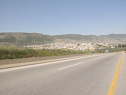
Nahf (Arabic: نحف, Naḥf or Nahef; Hebrew: נַחְף) is an Arab town in the Northern District of Israel. It is located in between the lower and upper Galilee, about 23 kilometres (14 mi) east of Acre. In 2015 it had a population of 12,145.
Remains have been found from Early Bronze IB, EB II, Middle Bronze Age II and Iron Age II, as has coins from the Ptolemaic dynasty and Antiochus III. Tombs from the 2nd to the 4th centuries have been found. Nahf contains Persian, Hellenistic and Roman remains.
From archeological finds, it is assumed that blown glass vessels were produced in the village during the Byzantine era. A bath, containing a hypocaust from the same period has also been excavated. Dating from the late Byzantine era, and was in continued use in the early Umayyad era.
In the Crusader era it was known as "Nef". In 1249 John Aleman transferred land, including the of Beit Jann, Sajur, Majd al-Krum and Nahf to the Teutonic Knights.
...
Wikipedia

