Myrhorod
|
Myrhorod Миргород |
|||
|---|---|---|---|
| City of regional significance | |||

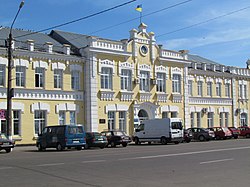
Myrhorod City Hall
|
|||
|
|||
 |
|||
| Coordinates: 49°58′N 33°36′E / 49.967°N 33.600°ECoordinates: 49°58′N 33°36′E / 49.967°N 33.600°E | |||
| Country | Ukraine | ||
| Oblast | Poltava Oblast | ||
| Raion | Myrhorod Raion | ||
| Founded | 1575 | ||
| Area | |||
| • Total | 20 km2 (8 sq mi) | ||
| Elevation | 105 m (344 ft) | ||
| Population (2015) | |||
| • Total | 40,603 | ||
| Website | myrgorod |
||
Myrhorod (Ukrainian: Ми́ргород) is a city in the Poltava Oblast (province) of central Ukraine. Serving as the administrative center of the Myrhorod Raion (district), the city itself is also designated as a separate raion within the oblast, and is located on the river Khorol.
The town was founded either in the 12th or 13th centuries as an eastern border fort of Kievan Rus'. According to legend, the fort was a place of peace negotiations that gave it its name (literally the City of Peace).
From 1471 to 1667 the town was part of the Kiev Voivodeship of the Grand Duchy of Lithuania and the Crown of the Kingdom of Poland.
Myrhorod was first mentioned in chronicles in 1575 when Stephen Bathory, King of Poland made it a regiment city. According to some historians, there was an earlier mentioning of the city in 1530, when the city coat of arms were established - yellow cross over an eight-pointed star, which signifies the victory of Christianity over Islam. Myrhorod was a royal city of Poland.
Myrhorod was the regimental base of the Myrhorod Cossacks who were very active in several Ukrainian Cossack uprisings, particularly during the peasants'-and-cossacks' revolt of 1638 under the leadership of Hetman Yakov Ostrianytsia against the Polish nobility (szlachta). The Myrhorod Cossack regiment was among the best units in the army of Hetman Bohdan Khmelnytsky during the Khmelnytsky Uprising (1648–1654).
...
Wikipedia


