Mt. Riga, New York
| North East, New York | ||
|---|---|---|
| Town | ||

Downtown Millerton, the main village in North East
|
||
|
||
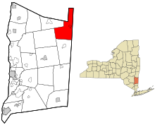
 Location of North East, New York |
||
| Location within the state of New York | ||
| Coordinates: 41°56′45″N 73°31′38″W / 41.94583°N 73.52722°WCoordinates: 41°56′45″N 73°31′38″W / 41.94583°N 73.52722°W | ||
| Country | United States | |
| State | New York | |
| County | Dutchess | |
| Government | ||
| • Type | Town Council | |
| • Town Supervisor | George Kaye (R) | |
| • Town Council |
Members' List
|
|
| Area | ||
| • Total | 43.72 sq mi (113.24 km2) | |
| • Land | 43.15 sq mi (111.77 km2) | |
| • Water | 0.57 sq mi (1.47 km2) | |
| Elevation | 1,017 ft (310 m) | |
| Population (2010) | ||
| • Total | 3,031 | |
| • Estimate (2016) | 2,967 | |
| • Density | 68.75/sq mi (26.55/km2) | |
| Time zone | Eastern (EST) (UTC-5) | |
| • Summer (DST) | EDT (UTC-4) | |
| ZIP code | 12546 (Millerton) | |
| FIPS code | 36-027-51891 | |
| GNIS feature ID | 0979285 | |
| Website | www |
|
North East is a town in Dutchess County, New York, United States. The population was 3,031 at the 2010 census. The town is in the northeast corner of the county. U.S. Route 44 crosses the town.
The town of North East takes its name from its position in the county. Part of the town was from the Great Nine Partners Patent of 1697, and part was from the Little Nine Partners Patent of 1706. The town was first settled by people from Connecticut, who located here from 1725 to 1730, in a separate area called "The Oblong", which was not part of the Patent.
The Town of Northeast was formed in 1788. Parts of the town were taken to form the towns of Milan (1818) and Pine Plains (1823).
In 1807, and for some time thereafter, a traveling Methodist minister would preach once a fortnight. A slate company was formed in the town in 1812.
During the Revolutionary War, iron ore was taken former the former Maltby ore bed (then known as the Dakin ore bed) to cast cannon for the American forces.
According to the United States Census Bureau, the town has a total area of 43.7 square miles (113.2 km2). 43.2 square miles (111.8 km2) of it is land and 0.54 square miles (1.4 km2), or 1.28%, is water.
The north town line is the border of Columbia County, New York, but a small part of the north town line borders Massachusetts. The east town line is the border of Connecticut.
...
Wikipedia


