Mount Pulag
| Mount Pulag | |
|---|---|
 |
|
| Highest point | |
| Elevation | 2,926 m (9,600 ft) |
| Prominence | 2,922 m (9,587 ft) Ranked 106th |
| Isolation | 668 kilometres (415 mi) |
| Listing | |
| Coordinates | 16°35′0.86″N 120°53′0.93″E / 16.5835722°N 120.8835917°ECoordinates: 16°35′0.86″N 120°53′0.93″E / 16.5835722°N 120.8835917°E |
| Geography | |
| Location | Luzon |
| Country | Philippines |
| Regions | |
| Provinces | |
| Municipalities | |
| Parent range | Cordillera Central |
| Climbing | |
| First ascent | c2000 BC by the native Ibalois. |
| Easiest route | Ambangeg Trail
|
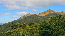
Mount Pulag (Ilocano: Bantay Pulag) and (Filipino: Bundok Pulag) is the 3rd highest mountain in the Philippines. It is Luzon’s highest peak at 2,922 metres (9,587 ft) above sea level. The borders between the provinces of Benguet, Ifugao, and Nueva Vizcaya meet at the mountain's peak.
It is the third highest mountain in the Philippines, next to Mount Apo and Mount Dulang-dulang.
Mount Pulag is famous for its "sea of clouds" and the view of the Milky Way Galaxy at dawn, which has attracted many tourists who wish to see the "other-worldly" scenery.
The Ibaloi people of Benguet mummify their dead and house in caverns in the mountain. The Kabayan mummy burial caves, one of the main attraction of the site, is considered as Philippine National cultural treasures under Presidential Decree No. 432.
Mt. Pulag was proclaimed a National Park through Pres. Proclamation No. 75 on February 20, 1987 covering an area of 11,550 hectares (28,500 acres). It is part of the Cordillera Biogeographic Zone and is a National Integrated Protected Areas Programme (NIPAP) site.
The National Park is inhabited by different ethnic groups such as the Ibalois, Kalanguya, Kankana-eys, Karao, Ifugaos and the Ilocanos.
Mount Pulag stands at 2,922 metres (9,587 ft) high. The peak of the mountain meet the borders of Benguet, Ifugao, and Nueva Vizcaya.
...
Wikipedia

