Mount Kaputar National Park
|
Mount Kaputar National Park New South Wales |
|
|---|---|
|
IUCN category II (national park)
|
|

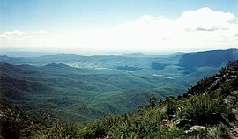
View of the park from the top of Mount Kaputar, oriented approximately west
|
|
| Coordinates | 30°17′26″S 150°08′34″E / 30.29056°S 150.14278°ECoordinates: 30°17′26″S 150°08′34″E / 30.29056°S 150.14278°E |
| Area | 368.17 km2 (142.2 sq mi) |
| Managing authorities |
|
| Footnotes | Managing Authorities |
| See also | Protected areas of New South Wales |
Mount Kaputar National Park is a national park in Australia, surrounding the proximities of Mount Kaputar, a volcano active between 17 and 21 million years ago. It is located 50 km (31 mi) east of Narrabri and 570 km (354 mi) northwest of Sydney. Millions of years of erosion have since carved the volcanic region into the lava terraces, volcanic plugs, and dykes of Nandewar Range. The central feature of the region is Mount Kaputar, the park's namesake, which rises to an altitude of 1,510 m (4,954 ft). The 360 degree view from the summit of the mountain encompasses about 1/10 of New South Wales' area or 80,000 km2 (31,000 sq mi).
The park protects a wide range of biomes, including semi-arid woodland, subalpine heath, and eucalypt forests, and provides a habitat for a range of animals, including bats, birds, wallabies, quolls, and the unique red triangle slug (Triboniophorus graeffei), which is known to appear after rainfall.
Before it was a national park, the area was used largely as grazing land for domestic animals. The conditions in the park are very harsh, but several pioneering families lived there, and remnants of their occupation remain. Sheep and cattle continued to graze on the plateau until around the 1950s. It was an isolated place, and the stockmen in charge of the cattle often would not see another human for months at a time.
...
Wikipedia

