Moss Vale, New South Wales
|
Moss Vale New South Wales |
|||||||||||||
|---|---|---|---|---|---|---|---|---|---|---|---|---|---|

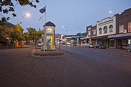
Argyle Street, which forms part of the Illawarra Highway
|
|||||||||||||
| Coordinates | 34°33′S 150°23′E / 34.550°S 150.383°ECoordinates: 34°33′S 150°23′E / 34.550°S 150.383°E | ||||||||||||
| Population | 7,792 (2011 census) | ||||||||||||
| Established | 1861 | ||||||||||||
| Postcode(s) | 2577 | ||||||||||||
| Location | 122 km (76 mi) from Sydney | ||||||||||||
| LGA(s) | Wingecarribee Shire | ||||||||||||
| Region | Southern Highlands | ||||||||||||
| County | Camden | ||||||||||||
| Parish | Bong Bong | ||||||||||||
| State electorate(s) | Goulburn | ||||||||||||
| Federal Division(s) | Whitlam | ||||||||||||
|
|||||||||||||
Moss Vale is a town in the Southern Highlands of New South Wales, Australia, in the Wingecarribee Shire. It has a population of 7,792 and is sited on the Illawarra Highway, which connects to Wollongong and the Illawarra coast via Macquarie Pass. The town is colloquially known as Mossy (Mozzy), and also Moss Vegas.
Moss Vale has several heritage buildings. In the centre of the main street is Leighton Gardens.
Moss Vale is believed to have fertile soil and good precipitation. Agricultural rural holdings in the area specialise in dairy herds, mainly Holstein Frisian, and there are an assortment of beef studs and sheep properties. The town has a commercial district and a golf course.
The Wingecarribee Shire Chambers are located here.
Moss Vale's poorer housing area is known to be called "Pill Hill".
The Moss Vale area was once occupied by the Gundangara people, though they had disappeared by the 1870s, partly due to the loss of their hunting land to European settlers. Governor Hunter sent a party led by ex-convict John Wilson to investigate the area in 1798. Various others explored the area up to 1815, including John Warby, George Caley, Hamilton Hume and John Oxley. Hume, Charles Throsby and Joseph Wild explored the area west of Sutton Forest in 1817 and in 1818, together with James Meehan, they explored the area between Moss Vale and Jervis Bay. Governor Macquarie granted Throsby 1,000 acres (4.0 km2), known as Throsby Park, at Bong Bong, on the northeastern outskirts of Moss Vale and put him in charge of building the Old Argyle Road from Sydney to Goulburn in 1819. This road was replaced in the 1830s by a more direct road via Berrima surveyed by Thomas Mitchell and most of the population of Bong Bong moved to Berrima. The heritage-listed property of Throsby Park house was built about 1834, six years after Throsby's suicide.
...
Wikipedia

