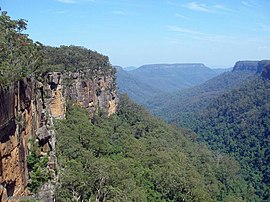
Southern Highlands, New South Wales
|
Southern Highlands New South Wales |
|||||||||||||
|---|---|---|---|---|---|---|---|---|---|---|---|---|---|

|
|||||||||||||
| Population | 44,379 (2006) | ||||||||||||
| Location |
|
||||||||||||
| LGA(s) | Wingecarribee Shire | ||||||||||||
| Region | Capital Country | ||||||||||||
| State electorate(s) |
• Goulburn • Kiama |
||||||||||||
| Federal Division(s) | • Whitlam | ||||||||||||
|
|||||||||||||
• Goulburn
The Southern Highlands, also locally referred to as the Highlands, is a geographical region and district in New South Wales, Australia and is 110 km south-west of Sydney. The entire region is under the local government area of the Wingecarribee Shire. The region is also considered a wine region.
The region specifically is the area centred on the commercial towns of Mittagong, Bowral, Moss Vale, Bundanoon and Robertson as well as the historic town of Berrima. Smaller villages like Burradoo, Sutton Forest, Colo Vale, Avoca, Yerrinbool, Exeter, Welby and many more that make up the Wingecarribee Shire are spread in between and around these main centres and serve mostly as residential areas.
The Highlands geographically sits between 500m and 900m above sea level on the Great Dividing Range. Like other regions along this plateau such as the Blue Mountains to the north and the Australian Alps to the south, the Southern Highlands is known for its cool temperate climate.
...
Wikipedia
