Morningside Heights
| Morningside Heights | |
|---|---|
| Neighborhood of Manhattan | |

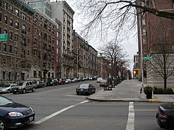
Residential buildings on West 116th Street opposite Columbia University
|
|
| Coordinates: 40°48′37″N 73°57′24″W / 40.810201°N 73.956601°WCoordinates: 40°48′37″N 73°57′24″W / 40.810201°N 73.956601°W | |
| Country |
|
| State |
|
| City |
|
| County/Borough | New York/Manhattan |
| Area | |
| • Total | 1.22 km2 (0.472 sq mi) |
| Population (2010) | |
| • Total | 55,929 |
| • Density | 46,000/km2 (120,000/sq mi) |
| ZIP codes | 10024, 10025, 10027 |
| Area code | 212, 646, 917 |
Morningside Heights is a neighborhood of the borough of Manhattan in New York City, on the border of the Upper West Side and Manhattanville. The area is usually described as being on the Upper West Side, but has been described as part of "Greater Harlem" due to a disputed claim that the Upper West Side goes no farther north than 110th Street.
Morningside Heights is bounded by Morningside Park at Morningside Drive to the east, Manhattanville and Harlem at 125th Street to the north, Manhattan Valley at 110th Street to the south, and Riverside Park at Riverside Drive to the west. The main thoroughfare is Broadway.
It is chiefly known as the home of educational and cultural institutions such as Columbia University, Teachers College, Barnard College, the Manhattan School of Music, Bank Street College of Education, "Grant's Tomb", Union Theological Seminary in the City of New York and the Jewish Theological Seminary of America. Additionally, Morningside Heights contains a number of religious institutions, including the Cathedral of Saint John the Divine, Riverside Church, the Church of Notre Dame, Corpus Christi Church, the Broadway Presbyterian Church and Interchurch Center. The neighborhood is also home to St. Luke's Hospital. Most of the neighborhood is part of New York's 10th congressional district since 2013.
...
Wikipedia
