Moravia (town), New York
| Moravia, New York | |
|---|---|
| Town | |

Town of Moravia, NY with the village of Moravia highlighted, 1904
|
|
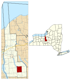
 Location within Cayuga County and New York |
|
| Coordinates: 42°42′48″N 76°25′18″W / 42.71333°N 76.42167°W | |
| Country | United States |
| State | New York |
| County | Cayuga |
| Government | |
| • Type | Town Council |
| • Town Supervisor | Gary W. Hatfield (R) |
| • Town Council |
Members' List
|
| Area | |
| • Total | 29.7 sq mi (76.8 km2) |
| • Land | 28.9 sq mi (74.8 km2) |
| • Water | 0.8 sq mi (2.0 km2) |
| Elevation | 745 ft (227 m) |
| Population (2010) | |
| • Total | 3,626 |
| • Density | 126/sq mi (48.5/km2) |
| Time zone | Eastern (EST) |
| ZIP code | 13118 |
| FIPS code | 36-011-48307 |
| Website | www |
Moravia is a town in Cayuga County, New York, United States. The population was 3,626 at the 2010 census.
The town of Moravia contains a village also called Moravia. The town is in the Finger Lakes region, south of Auburn.
Moravia was part of the Central New York Military Tract. The first settlers arrived around 1789, while the natives still lived in the area. The town was formed in 1833 from the town of Sempronius. Moravia was long known as the last bastion of the Whigs, the defunct political party of native ex-U.S. president Milliard Fillmore. A few Whigs survived as late as the early 1980s according to voter registration records.
According to the United States Census Bureau, the town has a total area of 29.7 square miles (76.8 km2), of which 28.9 square miles (74.8 km2) is land and 0.77 square miles (2.0 km2), or 2.54%, is water.
Moravia is at the south end of Owasco Lake, and the Owasco Inlet flows northward through the town to the lake. Mill Creek flows into the Owasco Inlet at Moravia village.
New York State Route 38 joins New York State Route 38A at Moravia village.
As of the census of 2000, there were 4,040 people, 1,003 households, and 685 families residing in the town. The population density was 139.3 people per square mile (53.8/km²). There were 1,198 housing units at an average density of 41.3 per square mile (15.9/km²). The racial makeup of the town was 72.30% White, 21.39% Black or African American, 0.27% Native American, 0.27% Asian, 5.35% from other races, and 0.42% from two or more races. Hispanic or Latino of any race were 9.98% of the population.
...
Wikipedia
