Moore, Texas
| Moore, Texas | |
|---|---|
| Census-designated place | |
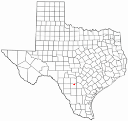
 Location of Moore, Texas |
|
 |
|
| Coordinates: 29°3′56″N 99°0′48″W / 29.06556°N 99.01333°WCoordinates: 29°3′56″N 99°0′48″W / 29.06556°N 99.01333°W | |
| Country | United States |
| State | Texas |
| County | Frio |
| Area | |
| • Total | 6.1 sq mi (15.8 km2) |
| • Land | 6.1 sq mi (15.8 km2) |
| • Water | 0.0 sq mi (0.0 km2) |
| Elevation | 663 ft (202 m) |
| Population (2010) | |
| • Total | 475 |
| • Density | 78/sq mi (30.1/km2) |
| Time zone | Central (CST) (UTC-6) |
| • Summer (DST) | CDT (UTC-5) |
| ZIP code | 78057 |
| Area code(s) | 830 |
| FIPS code | 48-49224 |
| GNIS feature ID | 1363092 |
Moore is an unincorporated community and census-designated place (CDP) in Frio County, Texas, United States. The population was 475 at the 2010 census.
Moore is located in northeastern Frio County at 29°03′56″N 99°00′48″W / 29.065636°N 99.013345°W (29.065636, -99.013345).Interstate 35 passes through the community, with access from Exit 114. I-35 leads northeast 44 miles (71 km) to downtown San Antonio and southwest 13 miles (21 km) to Pearsall, the Frio County seat.
According to the United States Census Bureau, the CDP as drawn in 2010 has a total area of 6.1 square miles (15.8 km2), down from an area of 31.2 square miles (81 km2) at the 2000 census. All of the CDP area is land.
As of the census of 2000, there were 644 people, 248 households, and 182 families residing in the CDP. The population density was 20.6 people per square mile (8.0/km2). There were 283 housing units at an average density of 9.1/sq mi (3.5/km2). The racial makeup of the CDP was 85.09% White, 0.47% African American, 1.40% Native American, 0.31% Pacific Islander, 10.09% from other races, and 2.64% from two or more races. Hispanic or Latino of any race were 46.27% of the population.
...
Wikipedia
