Pearsall, Texas
| Pearsall, Texas | |
|---|---|
| City | |

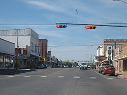
Downtown Pearsall
|
|
 Location of Pearsall, Texas |
|
| Coordinates: 28°53′29″N 99°5′42″W / 28.89139°N 99.09500°WCoordinates: 28°53′29″N 99°5′42″W / 28.89139°N 99.09500°W | |
| Country | United States |
| State | Texas |
| County | Frio |
| Area | |
| • Total | 5.95 sq mi (15.41 km2) |
| • Land | 5.93 sq mi (15.37 km2) |
| • Water | 0.02 sq mi (0.04 km2) |
| Elevation | 633 ft (193 m) |
| Population (2010) | |
| • Total | 9,146 |
| • Density | 1,541/sq mi (595.1/km2) |
| Time zone | Central (CST) (UTC-6) |
| • Summer (DST) | CDT (UTC-5) |
| ZIP code | 78061 |
| Area code(s) | 830 |
| FIPS code | 48-56384 |
| GNIS feature ID | 1364941 |
| Website | cityofpearsall |
Pearsall (/ˈpɪərsɔːl/ PIERCE-all) is a city in and the county seat of Frio County, Texas, United States. The population was 9,146 at the 2010 census, up from 7,157 at the 2000 census.
Pearsall is located near the center of Frio County at 28°53′29″N 99°5′42″W / 28.89139°N 99.09500°W (28.891458, -99.094873).Interstate 35 bypasses the city on the west side, with access from Exits 99, 101, and 104. I-35 leads northeast 55 miles (89 km) to San Antonio and south 100 miles (160 km) to Laredo.
According to the United States Census Bureau, Pearsall has a total area of 5.9 square miles (15.4 km2), of which 0.02 square miles (0.04 km2), or 0.27%, is water.
In 2003, Pearsall annexed the unincorporated neighborhood of West Pearsall, increasing the population of the town by about 350 people.
...
Wikipedia
