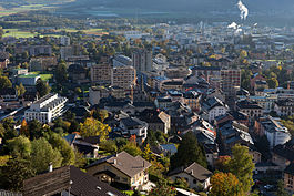
Monthey
| Monthey | ||
|---|---|---|
 |
||
|
||
| Coordinates: 46°15′N 6°57′E / 46.250°N 6.950°ECoordinates: 46°15′N 6°57′E / 46.250°N 6.950°E | ||
| Country | Switzerland | |
| Canton | Valais | |
| District | Monthey | |
| Government | ||
| • Mayor | Stéphane Coppey CVP/PDC | |
| Area | ||
| • Total | 28.63 km2 (11.05 sq mi) | |
| Population (Dec 2015) | ||
| • Total | 17,512 | |
| • Density | 610/km2 (1,600/sq mi) | |
| Demonym(s) | Les Montheysans | |
| Postal code | 1870 | |
| SFOS number | 6153 | |
| Surrounded by | Bex (VD), Châtel (FR-74), Collombey-Muraz, Massongex, Montriond (FR-74), Ollon (VD), Troistorrents, Val-d'Illiez, Vérossaz | |
| Twin towns | Diekirch (Luxembourg), Ivrea (Italy), Tübingen (Germany), Göd (Hungary) | |
| Website |
www SFSO statistics |
|
Monthey is the capital of the district of Monthey in the canton of Valais in Switzerland.
The castle in the town center was built in 950 on a hill, the first houses of Monthey surrounded it. Monthey is first mentioned in 1215 as Montez. At the 13th century, the counts of Savoy owned the village and its area. In 1352, the count Amédée VI gave more freedom to the inhabitants. During the first part of the 14th century, there were several industries including silk production and grinding mills.
Monthey has an area, as of 2009[update], of 28.6 square kilometers (11.0 sq mi). Of this area, 7.86 km2 (3.03 sq mi) or 27.5% is used for agricultural purposes, while 12.91 km2 (4.98 sq mi) or 45.1% is forested. Of the rest of the land, 5.47 km2 (2.11 sq mi) or 19.1% is settled (buildings or roads), 0.43 km2 (0.17 sq mi) or 1.5% is either rivers or lakes and 1.91 km2 (0.74 sq mi) or 6.7% is unproductive land.
Of the built up area, industrial buildings made up 3.9% of the total area while housing and buildings made up 8.4% and transportation infrastructure made up 4.3%. Power and water infrastructure as well as other special developed areas made up 1.6% of the area Out of the forested land, 40.7% of the total land area is heavily forested and 1.8% is covered with orchards or small clusters of trees. Of the agricultural land, 5.6% is used for growing crops and 4.8% is pastures and 16.2% is used for alpine pastures. Of the water in the municipality, 0.5% is in lakes and 1.0% is in rivers and streams. Of the unproductive areas, 5.1% is unproductive vegetation and 1.6% is too rocky for vegetation.
The municipality is the capital of the Monthey District. This urban center of the Chablais region is located on an alluvial fan of the Vieze on the left bank of the Rhône, at the entrance to Val d'Illiez and the Pas de Morgins which leads to Val d'Abondance. It consists of the town of Monthey, the villages of Outrevièze and Choëx and exclaves in Collombey-Muraz. Monthey is located on the west side of the Rhône valley, south to the Leman Lake.
...
Wikipedia


