Mont Cenis Pass
| Col du Mont Cenis | |
|---|---|

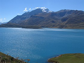
Lake at the pass
|
|
| Elevation | 2,083 m (6,834 ft) |
| Traversed by | Route nationale 6 |
| Location | Savoie, France |
| Range | Graian Alps/Cottian Alps |
| Coordinates | 45°15′37″N 06°54′03″E / 45.26028°N 6.90083°ECoordinates: 45°15′37″N 06°54′03″E / 45.26028°N 6.90083°E |
|
Location of Col de Mont Cenis
|
|
Mont Cenis (Italian: Moncenisio) is a massif (el. 3,612 m / 11,850 ft) and pass (el. 2081 m / 6827 ft) in Savoie (France), which forms the limit between the Cottian and Graian Alps.
The pass connects Val-Cenis in France in the northwest with Susa in Italy in the southeast. In the Middle Ages, pilgrims passing through Moncenisio and Susa Valley came to Turin along a road called Via Francigena, with final destination Rome. It was one of the most used Alpine pass in from the Middle Ages to the nineteenth century. The pass was part of the border between the two countries from the annexion of Savoy to the third French Empire in 1861 until 1947 Treaty of Paris, but is now located completely in France. The treaty allowed Savoy to retrieve its historical and political boundaries.
A road over the pass was built between 1803 and 1810 by Napoleon. The Mont Cenis Pass Railway was opened alongside the road in 1868, but was dismantled in 1871, on the opening of the Fréjus Rail Tunnel. It was the first ever railway based on the Fell mountain railway system and was worked by English engine-drivers. The Fréjus Rail Tunnel acquired the alternative, and geographically incorrect, name of Mont Cenis Tunnel because the traffic which formerly used the Mont Cenis Pass was transferred to it.
This tunnel (highest point 1295 m / 4249 ft) is really 27.4 km 17 miles west of the pass, below the Col du Fréjus. From Chambéry the line runs up the Isère valley, but soon bears through that of the Arc or the Maurienne past Saint-Jean-de-Maurienne to Modane (98.2 km / 61 mi from Chambéry). The tunnel is 13 km in length, and leads to Bardonecchia, some way below which, at Oulx the line joins the road from the Col de Montgenèvre.
...
Wikipedia

