Miami County, Kansas
| Miami County, Kansas | |
|---|---|
| County | |

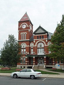
Miami County Courthouse in Paola
|
|
 Location in the U.S. state of Kansas |
|
 Kansas's location in the U.S. |
|
| Founded | August 25, 1855 |
| Named for | Miami tribe |
| Seat | Paola |
| Largest city | Paola |
| Area | |
| • Total | 590 sq mi (1,528 km2) |
| • Land | 576 sq mi (1,492 km2) |
| • Water | 15 sq mi (39 km2), 2.5% |
| Population | |
| • (2010) | 32,787 |
| • Density | 57/sq mi (22/km²) |
| Congressional districts | 2nd, 3rd |
| Time zone | Central: UTC-6/-5 |
| Website | MiamiCountyKS |
Coordinates: 38°35′N 94°51′W / 38.583°N 94.850°W
Miami County (county code MI) is a county located in east-central Kansas. As of the 2010 census, the county population was 32,787. Its county seat and most populous city is Paola.
The first settlements of the area were by Native American Indian tribes, primarily in the 1820s through the 1840s. This was due to their removal from areas east (Ohio, Illinois and Indiana)and the designation of the area as part of the Indian Territory. The tribes included were the Miami and Shawnee, and the Pottawatomie, Piankeshaw, Kaskaskia, Wea and Peoria, which comprised the Confederated Tribes. The original Miami reservation consisted of approximately 500,000 acres (2,000 km2). Early white settlers during that time were primarily serving as missionaries to the tribes. Over time, other settlers continued to arrive to build homes on the Miami reservation, and by 1854, the U.S. Government purchased all but 72,000 acres (290 km2) from the Miami tribe.
...
Wikipedia
