Megino-Kangalassky District
| Megino-Kangalassky District Мегино-Кангаласский улус (Russian) Мэҥэ Хаҥалас улууһа (Yakut) |
|
|---|---|
 Location of Megino-Kangalassky District in the Sakha Republic |
|
| Coordinates: 61°58′N 129°55′E / 61.967°N 129.917°ECoordinates: 61°58′N 129°55′E / 61.967°N 129.917°E | |
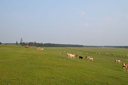
 Grazing livestock near the selo of Mayya in Megino-Kangalassky District |
|
|
|
|
| Location | |
| Country | Russia |
| Federal subject | Sakha Republic |
| Administrative structure (as of June 2009) | |
| Administrative center | selo of Mayya |
| Administrative divisions: | |
| Settlements | 1 |
| Rural okrugs | 29 |
| Inhabited localities: | |
| Urban-type settlements | 1 |
| Rural localities | 35 |
| Municipal structure (as of April 2012) | |
| Municipally incorporated as | Megino-Kangalassky Municipal District |
| Municipal divisions: | |
| Urban settlements | 1 |
| Rural settlements | 30 |
| Statistics | |
| Area (June 2009) | 11,700 km2 (4,500 sq mi) |
| Population (2010 Census) | 31,278 inhabitants |
| • Urban | 11.2% |
| • Rural | 88.8% |
| Density | 2.67/km2 (6.9/sq mi) |
| Time zone | YAKT (UTC+09:00) |
| Established | February 10, 1930 |
| Official website | |
| on | |
| 2010 Census | 31,278 |
|---|---|
| 2002 Census | 32,288 |
| 1989 Census | 31,623 |
| 1979 Census | 27,636 |
Megino-Kangalassky District (Russian: Ме́гино-Кангала́сский улу́с; Sakha: Мэҥэ Хаҥалас улууһа, Meñe Xañalas uluuha, IPA: [meŋe xaŋalas uluːha]) is an administrative and municipal district (raion, or ulus), one of the thirty-four in the Sakha Republic, Russia. It is located in the central part of the republic, on the Lena River opposite Yakutsk, the capital of the republic. It borders Ust-Aldansky District in the north, Churapchinsky District in the east, Amginsky District in the southeast, Khangalassky District in the southwest, and is bounded by the Lena River in the west. The area of the district is 11,700 square kilometers (4,500 sq mi). Its administrative center is the rural locality (a selo) of Mayya. As of the 2010 Census, the total population of the district was 31,278, with the population of Mayya accounting for 23,.3% of that number.
The district was established on February 10, 1930 through the merger of Meginsky and Vostochno-Kangalassky Districts.
Within the framework of administrative divisions, Megino-Kangalassky District is one of the thirty-four in the republic. It is divided into one settlement (an administrative division with the administrative center in the urban-type settlement (inhabited locality) of Nizhny Bestyakh) and twenty-nine rural okrugs (naslegs), all of which comprise thirty-five rural localities. The selo of Mayya serves as its administrative center.
...
Wikipedia

